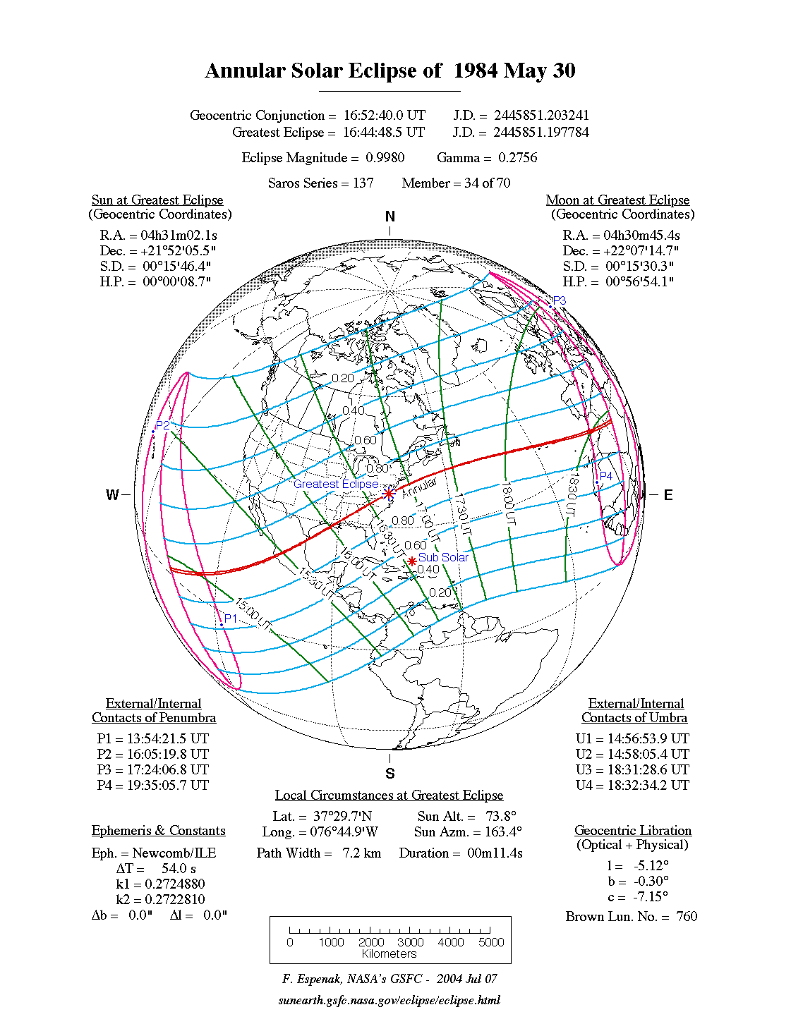
An annular eclipse of the Sun occurred on Wednesday 30 May, 1984 UT, lasting from 13:54–19:35 UT. A large annular eclipse covered over 99% of the Sun, creating a dramatic spectacle for observers in only a tiny path, just 7 km wide; it lasted a brief 11 seconds at the point of maximum eclipse. It was seen across northern Mexico, the south-eastern United States, the Azores, Morocco, and Algeria. The partial eclipse was visible from North America, western Europe, and north-west Africa.
The timings of the phases of the overall eclipse
worldwide are as follows. In any particular
place it would have been seen for a significantly shorter
duration as the shadow moved across the Earth:
| Partial eclipse began: |
13:54:21 UT |
| Annular eclipse began: |
14:56:54 UT |
| Maximum eclipse: |
16:44:48 UT |
| Annular eclipse ended: |
18:32:34 UT |
| Partial eclipse ended: |
19:35:06 UT |
During this eclipse the Sun was 0.526° in apparent
diameter, 1.4% smaller than average. The Moon was 6 days after apogee and 8 days before perigee.
At maximum eclipse it was 0.525° in
apparent diameter, which is 1.2% smaller than average; this was not
large enough to cover the Sun, which is why this
was an annular eclipse.
The statistics page has information on the ranges of the sizes of
the Sun and Moon, and the Moon data page displays detailed
information on the Moon's key dates.
The Annular Eclipse
Mexico
The annular eclipse began in the Pacific, and then reached land at Jalisco in Mexico at 15:26 UT. At this point the annular eclipse lasted 36 seconds, and was visible from a path 30 km (18.6 miles) wide. The path of the eclipse passed close to Guadalajara and over San Luis Potosi and Ciudad Victoria, then reached the Gulf of Mexico at Laguna Madre at 15:44 UT. With the eclipse getting closer to maximum, the duration was down to 26 seconds and the path width 20 km (12.4 miles).
USA
The annular eclipse reached the US mainland in Louisiana at 16:02 UT, with the path width down to 14 km (8.7 miles) and the duration just 19 seconds. It then crossed southern Mississippi, Alabama, Georgia, South Carolina, North Carolina, Virginia, the Chesapeake, and the south-east corner of Maryland. The point of greatest eclipse (which, for an annular eclipse, is the point of shortest duration) was on the York River, where the duration was just 11 seconds in the centre of a path just 7 km (4.3 miles) wide.
Azores
The path of the annular eclipse clipped the island of Corvo at 18:11 UT, then passed over Graciosa at 18:14 UT. The north of the island was fairly close to the centreline, where the duration was up to 38 seconds. The north coast of Terceira saw a brief annular eclipse at 18:15 UT.
Africa
The annular eclipse reached land again in Morocco at 18:29 UT, with the path width now up to 52 km (32.3 miles) and the duration 51 seconds on the centreline. The path of the annular eclipse crossed Morocco south-east into Algeria, where it ended north of Ain Salah minutes later.
The Partial Eclipse
The Americas
The partial eclipse was visible over all of North America except the Yukon and Alaska. A 60% eclipse was seen south-east of Arizona, Colorado, Nebraska, Minnesota, and central Ontario and Quebec, and north-west of Honduras and Cuba. The eastern and south-eastern US, from Texas to Maine, enjoyed an 80% eclipse, as did most of Mexico and Florida. Maximum eclipse was around 15:30 UT in western Mexico and 17:30 UT in maritime Canada.
Europe
Western Europe saw the partial eclipse in the afternoon and evening, with the greatest eclipse seen in the south. North-West Scotland saw a 40% eclipse with maximum around 18:00 UT; southern England saw an eclipse of 45% - 55% just a few minutes later. At the University of Kent in Canterbury, for example, 47.7% of the Sun's diameter was covered by the Moon at maximum eclipse, which occurred at 18:09:02 UT. The partial eclipse lasted from 17:15–19:00 UT; the Sun set at 20:00 UT.
A 60% eclipse was seen south of central France, but farther east the sun set during the eclipse.
Interactive Map
This map shows the visibility of the eclipse.
The shaded area saw the annular solar eclipse; however, near the edges of
this area, the eclipse was very short. The bold line shows the centre
of the path, where the eclipse lasted longest.
Use the zoom controls to zoom in and out; hover your mouse over any
point on the centreline to see the time and
duration of the eclipse at that point. You can pan and zoom the map to
see detail for any part of the eclipse path.
The interactive map is currently not available.
Overview Map
This map sourced from NASA Goddard Space flight Center: GSFC Eclipse Web SiteGSFC Eclipse Web Site
The primary source of all the information on eclipses presented here at Hermit Eclipse. (NASA Goddard Space flight Center)
shows the visibility of the annular solar eclipse. It also shows the broader area in which a partial eclipse was seen. (Click on it for the
full-sized version.)
Eclipse Season and Saros Series
This eclipse season contains 3 eclipses:
This was the 34th eclipse in solar Saros series 137.The surrounding eclipses in this Saros series are:
This Saros series, solar Saros series 137,
is linked to lunar Saros series 130. The
nearest partner eclipses in that series are:
Eclipse Parameters
| UT Date/time (max) | 16:44:47 on 30 May UT |
TDT Date/time (max) | 16:45:41 on 30 May TDT |
| Saros Series | 137 |
Number in Series | 34 |
| Penumbral Magnitiude | |
Central Magnitiude | 0.998 |
| Gamma | 0.2755 |
Path Width (km) | 7 |
| Delta T | 0m54s |
Error | ± 0m00s (95%) |
| Penumbral Duration | |
Partial Duration | |
| Total Duration | 0m11s |
| |
| Partial Rating | |
Total Rating | |
| Sun Distance | 151686627 km (95.0%) |
Moon Distance | 385367 km (57.6%) |
| Sun Diameter | 0.526° |
Moon Diameter | 0.517° - 0.525° |
| Apogee | 00:59 on 24 May UT |
Perigee | 11:15 on 7 Jun UT |
| Contact p1 | 13:54:21 on 30 May UT |
Contact p2 | |
| Contact u1 | 14:56:54 on 30 May UT |
Contact u2 | 14:58:05 on 30 May UT |
| Max eclipse | 16:44:48 on 30 May UT |
| Contact u3 | 18:31:29 on 30 May UT |
Contact u4 | 18:32:34 on 30 May UT |
| Contact p3 | |
Contact p4 | 19:35:06 on 30 May UT |
Note that while all dates and times on this site (except
where noted) are in UT, which is within a second of civil time,
the dates and times shown in NASA's eclipse listingsGSFC Eclipse Web Site
The primary source of all the information on eclipses presented here at Hermit Eclipse. (NASA Goddard Space flight Center)
are in the TDT timescale.
The Sun and Moon distances are shown in km, and as a
percentage of their minimum - maximum distances; hence 0%
is the closest possible (Earth's perihelion, or the
Moon's closest possible perigee) and 100% is
the farthest (aphelion, the farthest apogee).
The statistics page has information on the ranges of sizes
of the Sun and Moon, and the Moon data page displays detailed
information on the Moon's key dates.
Data last updated: 2015-06-21 22:11:46 UTC.