We have a
special site for this eclipse!
Information from moonblink.info on the total solar eclipse of 11 August 1999, visible from Cornwall, UK and mainland Europe and Asia. Maps and descriptions of the path, with links to other resources.
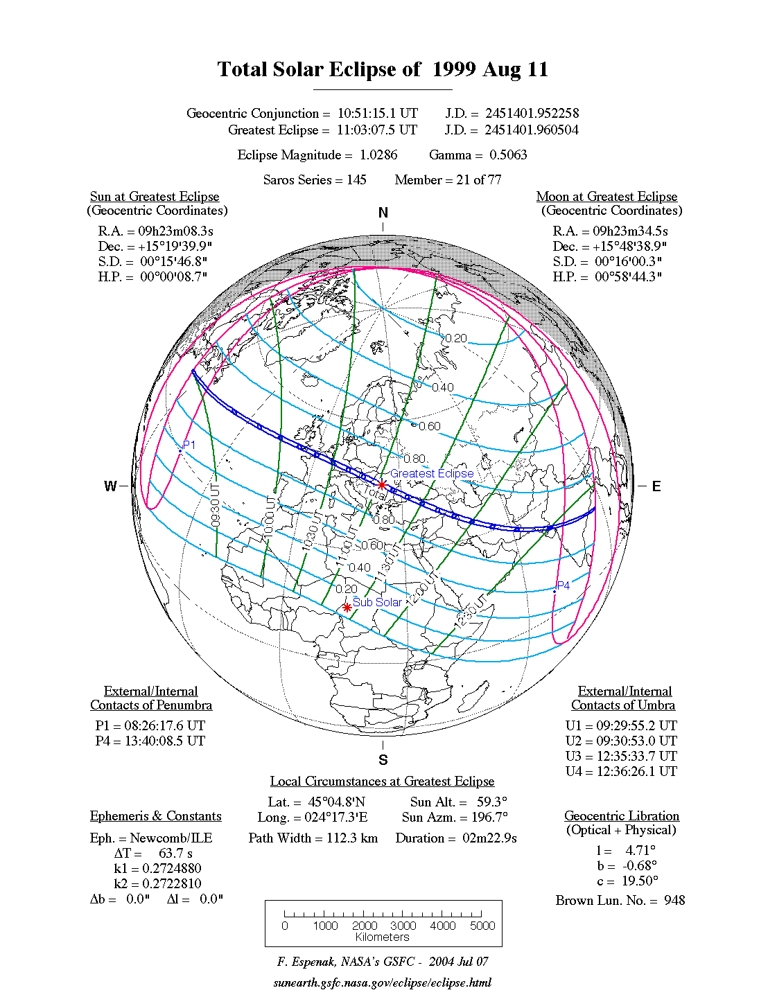
A total eclipse of the Sun occurred on Wednesday 11 August, 1999 UT, lasting from 08:26–13:40 UT. A dramatic total eclipse plunged the Sun into darkness for 2 minutes and 23 seconds at maximum, creating an amazing spectacle for observers in a path up to 112 km wide. It was seen from the South-West corner of England, much of mainland Europe, the Middle East and South Asia. The partial eclipse was visible in the north-eastern U.S., Europe, the Middle East, western Asia, and northern Africa.
The timings of the phases of the overall eclipse
worldwide are as follows. In any particular
place it would have been seen for a significantly shorter
duration as the shadow moved across the Earth:
| Partial eclipse began: |
08:26:18 UT |
| Total eclipse began: |
09:29:55 UT |
| Maximum eclipse: |
11:03:07 UT |
| Total eclipse ended: |
12:36:26 UT |
| Partial eclipse ended: |
13:40:08 UT |
During this eclipse the Sun was 0.526° in apparent
diameter, 1.3% smaller than average. The Moon was just 3 days past perigee, making it relatively large.
At the start and end of the eclipse the Moon
was 0.533°, and at maximum eclipse 0.541°,
which is 1.9% larger than average; hence it covered the Sun,
making this a total eclipse.
The statistics page has information on the ranges of the sizes of
the Sun and Moon, and the Moon data page displays detailed
information on the Moon's key dates.
The final total solar eclipse of the millennium (there was none in 2000) was quite literally a once-in-a-lifetime chance for millions of people — the last total eclipse in the UK mainland was in 1927, and the next is in 2090! Even Europe will not see such an event again until 2081. This eclipse is from the same Saros series as the famous British total eclipse of Jun 29 1927, although it does not belong to the same triple Saros.
Detailed Path Description
For a very detailed description of the eclipse path, see the special page for this eclipse.
The British Isles
The centre of the track of total eclipse hits the British mainland north of Land's End at 10:11:30 UT. The total eclipse here will last a fraction over 2 minutes and 1 second. The path moves east, over southern Cornwall, and then crosses the southern tip of Devon just after 10:13 UT. Alderney in the Channel Islands see the total eclipse at around 10:16 UT.
Europe
The eclipse path passes over orthern France, and touches Belgium and Luxembourg, before crossing into Germany; Metz will see 2m13s of totality at 10:29 UT, and Stuttgart sees 2m17s at 10:34 UT.
Austria is particularly fortunate to have the path of total eclipse pass right through the country; and although Vienna will see at most a 99% partial eclipse (with the maximum at 10:46 UT), a good number of Austrian towns are in the path of totality. Kapfenberg is eclipsed for 2m16s at 10:45 UT.
In Hungary, Siófok, on Lake Balaton, is right on the centreline, with 2m22s of totality at 10:50 UT. After this, the eclipse path partially cuts across Yugoslavia and then across Romania, covering many towns and cities. Râmnicu-Vâlcea is close to the centreline, and, what's more, close to the point of maximum eclipse; it will see 2m22s of totality at 11:03 UT.
Middle East, South Asia
The eclipse path cuts into Bulgaria and crosses the Black Sea, then into northern Turkey at 11:21 UT. In southeast Turkey, Divrigi, close to the centreline, will be eclipsed for 2m12s, at 11:34 UT. The path then cuts briefly across north-eastern Syria, and crosses northern Iraq; Zakhu is almost exactly on the centreline, and will be under total eclipse for 2m05s at 11:45 UT.
As the total eclipse passes into Iran, the centreline duration drops below 2 minutes. Borujerd, close to the centreline, is eclipsed for 1m53s at 11:58 UT. The track then passes through south-western Pakistan; Karachi is eclipsed for 01m13s at 12:26 UT.
The eclipse track enters India close to local sunset. Dhrangadhra sees 1m05s of total eclipse at 12:30 UT. The total eclipse passes through a region around Shahada at around 12:32 UT which will also see the total eclipse of July 2009. One of the last places on land to see a total eclipse will be Srikakulam, near the bay of Bengal, for 25 seconds at 12:36 UT; the centreline duration will be 42 seconds.
Finally, the eclipse finishes in the Bay of Bengal, at local sunset, 12:36:23 UT.
Interactive Map
This map shows the visibility of the eclipse.
The shaded area saw the total solar eclipse; however, near the edges of
this area, the eclipse was very short. The bold line shows the centre
of the path, where the eclipse lasted longest.
Use the zoom controls to zoom in and out; hover your mouse over any
point on the centreline to see the time and
duration of the eclipse at that point. You can pan and zoom the map to
see detail for any part of the eclipse path.
The interactive map is currently not available.
Overview Map
This map sourced from NASA Goddard Space flight Center: GSFC Eclipse Web SiteGSFC Eclipse Web Site
The primary source of all the information on eclipses presented here at Hermit Eclipse. (NASA Goddard Space flight Center)
shows the visibility of the total solar eclipse. It also shows the broader area in which a partial eclipse was seen. (Click on it for the
full-sized version.)
Eclipse Season and Saros Series
This eclipse season contains 2 eclipses:
This was the 21st eclipse in solar Saros series 145.The surrounding eclipses in this Saros series are:
This Saros series, solar Saros series 145,
is linked to lunar Saros series 138. The
nearest partner eclipses in that series are:
Eclipse Parameters
| UT Date/time (max) | 11:03:05 on 11 Aug UT |
TDT Date/time (max) | 11:04:09 on 11 Aug TDT |
| Saros Series | 145 |
Number in Series | 21 |
| Penumbral Magnitiude | |
Central Magnitiude | 1.0286 |
| Gamma | 0.5062 |
Path Width (km) | 112 |
| Delta T | 1m04s |
Error | ± 0m00s (95%) |
| Penumbral Duration | |
Partial Duration | |
| Total Duration | 2m23s |
| |
| Partial Rating | |
Total Rating | |
| Sun Distance | 151629172 km (93.8%) |
Moon Distance | 373317 km (33.6%) |
| Sun Diameter | 0.526° |
Moon Diameter | 0.533° - 0.541° |
| Perigee | 23:35 on 7 Aug UT |
Apogee | 23:28 on 19 Aug UT |
| Contact p1 | 08:26:18 on 11 Aug UT |
Contact p2 | |
| Contact u1 | 09:29:55 on 11 Aug UT |
Contact u2 | 09:30:53 on 11 Aug UT |
| Max eclipse | 11:03:07 on 11 Aug UT |
| Contact u3 | 12:35:34 on 11 Aug UT |
Contact u4 | 12:36:26 on 11 Aug UT |
| Contact p3 | |
Contact p4 | 13:40:08 on 11 Aug UT |
Note that while all dates and times on this site (except
where noted) are in UT, which is within a second of civil time,
the dates and times shown in NASA's eclipse listingsGSFC Eclipse Web Site
The primary source of all the information on eclipses presented here at Hermit Eclipse. (NASA Goddard Space flight Center)
are in the TDT timescale.
The Sun and Moon distances are shown in km, and as a
percentage of their minimum - maximum distances; hence 0%
is the closest possible (Earth's perihelion, or the
Moon's closest possible perigee) and 100% is
the farthest (aphelion, the farthest apogee).
The statistics page has information on the ranges of sizes
of the Sun and Moon, and the Moon data page displays detailed
information on the Moon's key dates.
Data last updated: 2015-06-21 22:11:46 UTC.