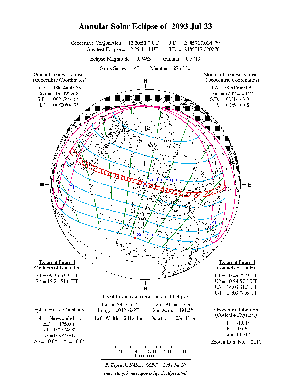
An annular eclipse of the Sun occurs on Thursday 23 July, 2093 UT, lasting from 09:36–15:21 UT. The Sun will be 95% covered in a moderate annular eclipse, lasting 5 minutes and 11 seconds and covering a very broad path, 241 km wide at maximum. It will be visible from north-eastern U.S.A, central Britain and the north of Ireland, across Europe and into south Asia. The partial eclipse will be visible in north-east North America, Europe, and north Africa.
The timings of the phases of the overall eclipse
worldwide are as follows. In any particular
place it will be seen for a significantly shorter
duration as the shadow moves across the Earth:
| Partial eclipse begins: |
09:36:33 UT |
| Annular eclipse begins: |
10:49:23 UT |
| Maximum eclipse: |
12:29:11 UT |
| Annular eclipse ends: |
14:09:05 UT |
| Partial eclipse ends: |
15:21:52 UT |
During this eclipse the Sun will be 0.525° in apparent
diameter, 1.5% smaller than average. The Moon will be just a day past apogee, making it very small.
At maximum eclipse it will be 0.497° in
apparent diameter, which is 6.5% smaller than average; this is not
large enough to cover the Sun, which is why this
is an annular eclipse.
The statistics page has information on the ranges of the sizes of
the Sun and Moon, and the Moon data page displays detailed
information on the Moon's key dates.
The annular eclipse will be visible over a broad track, including most of Northern Ireland, Glasgow, and Edinburgh. The centreline crosses the British mainland from Ayr to Newcastle. The central duration will be over 5 minutes.
Interactive Map
This map shows the visibility of the eclipse.
The shaded area will see the annular solar eclipse; however, near the edges of
this area, the eclipse will be very short. The bold line shows the centre
of the path, where the eclipse will last longest, so this is where you want to be if possible.
Use the zoom controls to zoom in and out; hover your mouse over any
point on the centreline to see the time and
duration of the eclipse at that point. You can pan and zoom the map to
see detail for any part of the eclipse path.
The interactive map is currently not available.
Overview Map
This map sourced from NASA Goddard Space flight Center: GSFC Eclipse Web SiteGSFC Eclipse Web Site
The primary source of all the information on eclipses presented here at Hermit Eclipse. (NASA Goddard Space flight Center)
shows the visibility of the annular solar eclipse. It also shows the broader area in which a partial eclipse will be seen. (Click on it for the
full-sized version.)
Eclipse Season and Saros Series
This eclipse season contains 2 eclipses:
This is the 27th eclipse in solar Saros series 147.The surrounding eclipses in this Saros series are:
This Saros series, solar Saros series 147,
is linked to lunar Saros series 140. The
nearest partner eclipses in that series are:
Eclipse Parameters
| UT Date/time (max) | 12:28:57 on 23 Jul UT |
TDT Date/time (max) | 12:32:04 on 23 Jul TDT |
| Saros Series | 147 |
Number in Series | 27 |
| Penumbral Magnitiude | |
Central Magnitiude | 0.9463 |
| Gamma | 0.5717 |
Path Width (km) | 241 |
| Delta T | 3m07s |
Error | ± 1m23s (95%) |
| Penumbral Duration | |
Partial Duration | |
| Total Duration | 5m11s |
| |
| Partial Rating | |
Total Rating | |
| Sun Distance | 151984484 km (101.1%) |
Moon Distance | 405961 km (98.5%) |
| Sun Diameter | 0.525° |
Moon Diameter | 0.490° - 0.497° |
| Apogee | 09:09 on 22 Jul UT |
Perigee | 03:52 on 6 Aug UT |
| Contact p1 | 09:36:33 on 23 Jul UT |
Contact p2 | |
| Contact u1 | 10:49:23 on 23 Jul UT |
Contact u2 | 10:54:57 on 23 Jul UT |
| Max eclipse | 12:29:11 on 23 Jul UT |
| Contact u3 | 14:03:31 on 23 Jul UT |
Contact u4 | 14:09:05 on 23 Jul UT |
| Contact p3 | |
Contact p4 | 15:21:52 on 23 Jul UT |
Note that while all dates and times on this site (except
where noted) are in UT, which is within a second of civil time,
the dates and times shown in NASA's eclipse listingsGSFC Eclipse Web Site
The primary source of all the information on eclipses presented here at Hermit Eclipse. (NASA Goddard Space flight Center)
are in the TDT timescale.
The Sun and Moon distances are shown in km, and as a
percentage of their minimum - maximum distances; hence 0%
is the closest possible (Earth's perihelion, or the
Moon's closest possible perigee) and 100% is
the farthest (aphelion, the farthest apogee).
The statistics page has information on the ranges of sizes
of the Sun and Moon, and the Moon data page displays detailed
information on the Moon's key dates.
Data last updated: 2015-06-21 22:11:46 UTC.