After some considerable preparation in Alameda -- but with a lot of things still up in the air -- it is time to head off down to San Diego. This trip, of 4 days or so, will serve as a shakedown cruise, to tell us what works and what doesn't; once in San Diego, we will finish preparing the boat there, then make our plans for the next step.
Our plan is to do the trip in one stretch, rather than harbour-hopping down the coast. One reason is to get an idea of how the boat -- and ourselves -- will perform on an offshore passage; but another reason is the shortage of safe harbours on the west coast.
We decided to make an early start to hit the ebb current at the Golden Gate Bridge, which always makes the exit from the bay easier; the ebb ends (and flood begins) at 9:45am. Getting to the bridge within an hour of this time, on either side, will ensure pretty much slack water, which is ideal; this means starting around 7:00 am.
 Sat 5 Apr 2003 07:39 US/Pacific
Bright and early -- only an hour or so later than planned -- we got under way from Grand Marina, Alameda.
Casting off the mooring lines from Alameda for possibly the last time -- after 3 years of sailing from there -- was a pretty exciting experience; this is where the adventure begins!
 Sat 5 Apr 2003 08:36 US/Pacific
Passed under the Bay Bridge D-E span, northbound.
 Sat 5 Apr 2003 09:25 US/Pacific
Passed under the Golden Gate Bridge, outbound -- probably for the last time in a long, long while. We hit the slack, right on the nose, so the water is pretty calm, not the jacuzzi it can sometimes be here.
Coming up to the bridge, we passed through a fleet of race boats, heading out for the singlehanded Farallones race. I say they were heading out; mainly they were drifting in very light airs, no doubt hoping for wind to appear before the flood current sets in. We wished them luck -- while trying to avoid a collision!
 Sat 5 Apr 2003 09:51 US/Pacific
Passed between Point Bonita and Point Lobos; we're now out of the Golden Gate.
The charge alarm on the regulator has been sounding, 3 seconds on and 3 off, but I've had problems with unwarranted alarms before. Setting the regulator to maintenance charge fixed it for a while, but it's going again -- and it doesn't seem to be charging while it's going.
The sea is getting wild! We're taking green water over the bow and sides -- very choppy.
(Phil MacFarlane was in the singlehanded Farallones race, and wrote for Latitude 38: "... It took at least an hour to get to the Golden Gate Bridge, but then the breeze finally filled in. By the time our 58-boat fleet got out past Land's End, it was blowing in the 20s and gusting higher, with 10-foot seas at 10-second intervals. Racers started dropping out like flies.")
 Sat 5 Apr 2003 11:00 US/Pacific
We're now exiting the line of buoys that mark the main ship channel through the SF bar, so we're into the ocean proper -- the sea is a little less choppy, but still rough. As usual, there are sea lions perched on all the buoys. Passing freighter Highland Light, who is coming into the channel; we're leaving her well to port.
Our plan was to get well offshore, then head south to avoid the nasty chop that tends to build in the shallower water; there's not much traffic about, so once we're between the ship channel and the sea buoy, we'll turn south.
 Sat 5 Apr 2003 12:46 US/Pacific
Now that we've got into the rhythm a bit, we set the staysail and killed the engine -- we're making 5 knots, and as always, it's a relief to get rid of the engine noise. The next step is to set the windvane self-steering, to dispense with the noisy electric autopilot and save battery power (specially as the batteries haven't been charging).
Unfortunately, when we lowered the windvane servo rudder, it broke away -- something it's designed to do when it hits something, to save it getting broken, but of course it should stay in place normally. I managed to get it reset -- very tricky while moving -- but it promptly broke away again. (Of course, it's attached to the boat by a lanyard, so we don't lose it.) The problem is that the bungee which normally holds it in place is weathered and weakened -- we'll need to make a new one before using it again. Went back to the electric pilot for now.
 Sat 5 Apr 2003 14:16 US/Pacific
Still sailing along in a nasty, lumpy chop, which is very tiring -- basically, your body is continually bracing against the movement of the boat, which means that all your muscles are working continuously. This is pretty typical stuff for the Gulf of the Farallones, and I'm hoping things will ease off further south.
However, given our problems -- the alternator not charging batteries and the windvane servo rudder failed -- we decided to put into Pillar Point Harbour, Half Moon Bay, for rest and repairs. Turned east, still under staysail.
We spoke Pillar Point Harbour and the VHF, and were assigned berth G-39, with a starboard tie-up. This is one of the larger fishing-boat berths, so should be relatively easy to get into.
 Sat 5 Apr 2003 16:33 US/Pacific
Docked at Pillar Point Harbour. We managed to negotiate the entrance hazards and find the slip OK -- I'm pretty familiar with the harbour by now -- but there was a nasty, strong cross wind blowing away from the finger we were trying to get into. Not only that, but we were sharing a double slip with a large fishing boat, which didn't leave much room to get in. The challenge is to blast into the slip quickly enough that we keep steerage and tracking way, and don't get blown into the other boat in the time it takes us to get into the slip; but then stop the boat before hitting the end!
Well, the first two attempts didn't go so well, but we managed to back out unscathed each time; on the third go we nailed it, and got safely tied up.
We plugged the shore power in, set the batteries charging, turned on the fridge, and went straight to bed and collapsed, exhausted.
Sun 6 Apr 2003 10:30 US/Pacific
Once in Pillar Point Harbour, we collapsed into bed, where we slept for 10 or 12 hours straight -- totally exhausted. The next day was bright and sunny, and we set about straightening the boat up.
The first problem to tackle was the alternator, which was sounding its 3 on, 3 off alarm and refusing to charge the batteries. On digging out the manual we found that this alarm means high battery temperature, which causes the regulator to shut down to avoid boiling the batteries.
Well, I didn't even know that the regulator had any way to measure the battery temperature, but on tracing wires from the regulator I found a pair that led to what looked like a disconnected ring terminal hanging in space. It turns out that this ring terminal incorporates a temperature sensor, which at some point must have been connected to the battery, but was for some reason now just dangling.
A check with the multimeter showed the reason for the alarm -- the lead to the sensor was corroded, and had a high resistance, which looks like high temperature to the regulator. Since this corrosion problem seemed likely to recur, causing inaccurate charging, and since the temperature sensor is optional in any case, I just disconnected it. Result -- charging batteries!
The other problem was the dangling windvane servo rudder. A new bungee loop was soon made up. While it could just about have been replaced from the boat at dock, the job was made much easier by the kind loan of a skiff from the fishing boat Promise next door. Thanks!
Sun 6 Apr 2003 18:30 US/Pacific
With the boat now back in order, we decided to head off on our way. An evening start is quite a nice way to go, because it gets you into the rhythms of standing night watches before you're too tired. So, we cast off -- then noticed that the bolt holding the autopilot bracket to the tiller had sheared!
We hastily re-tied the boat, then started looking for a replacement bolt for this bracket, which attaches the electric autopilot to the tiller. Since we couldn't find a bolt, we jury-rigged a repair with duct tape and a C-clamp. After all, we can still hand steer, plus we have the windvane autopilot (hopefully).
Sun 6 Apr 2003 18:50 US/Pacific
Cast off again! Heading out under power.
Sun 6 Apr 2003 19:45 US/Pacific
Heading southwest; raised the main with 2 reefs in and the staysail, and turned off the engine. The wind is moderate, and the seas pretty calm -- lovely clear sky and sunset. The crescent moon is high in the sky.
This is another milestone for me; the point at which we sail into waters I've never sailed before...
Sun 6 Apr 2003 20:20 US/Pacific
The wind is down a little, so we raised the jib to improve balance, keeping the second reef in the main; we're sailing nicely on a broad reach on the starboard tack.
Sun 6 Apr 2003 23:00 US/Pacific
Clear sky and moonglade. We're making 2.5-3 knots in a light northwest wind; the second reef has been taken out.
Mon 7 Apr 2003 05:00 US/Pacific
The wind's light, so we're now motoring along nicely. It's quite eerie sailing along in the darkness -- there's not another soul in sight, and not many lights on land; the lighthouse on Pigeon Point is fading astern, and the land is pretty much dark otherwise. There's been no traffic since a freighter passed well off the starboard beam an hour ago. Motoring at 5.9 knots under a clear sky.
Mon 7 Apr 2003 07:10 US/Pacific
A beautiful morning -- still calm, mostly clear. Venus was up in the east as the sky was pinking; 20 minutes ago we had a beautiful sunrise. There's still no-one else about.
We're about half-way down Monterey bay, and looking for whales, but no luck yet. I did, however, see my first albatross! We've been seeing vellella all along the coast; but they're very thick here. Not much other wildlife.
Mon 7 Apr 2003 10:08 US/Pacific
The wind's up -- we set the mainsail with the second reef. We're sailing at over 6 knots!
Mon 7 Apr 2003 16:10 US/Pacific
The wind is 20+ knots out of the northwest -- we shook out the second reef a while ago, but we're still sailing with just the main, and we're making 5.6 knots. Sky is clear, and there's no traffic about.
A while ago a power vessel -- it looked like a fishing boat -- passed north closer to shore; that was the first sign of life in a long time.
Mon 7 Apr 2003 19:35 US/Pacific
Sunset. The Sun was very round and clear, with wisps of cloud above -- beautiful. The weather is nice, and getting noticeably warmer.
2 boats just passed going north close inshore; one probably a fishing boat, one has a black hull with an orange mark near the bow -- may be a coastguard buoy tender.
Mon 7 Apr 2003 20:00 US/Pacific
The light on Point Piedras Blancas is visible off to port -- flashing white every 10 seconds. This is the only sign of life on this coast for many miles. We have a clear sky with lots of stars, and it's getting chilly.
Tue 8 Apr 2003 09:03 US/Pacific
The sun's up! We started the engine during the night due to light winds, and now we're motoring along in a very clear, sunny day, which is great; but the foul-weather gear is still on. There's some haze inshore, but visibility is otherwise good. Before dawn, we had a nice peachy glow on the eastern horizon under the clear sky.
There are many vellella still about, but not much other wildlife, and no traffic.
Tue 8 Apr 2003 10:45 US/Pacific
During this long sail down the coast -- over three days now -- we've been looking forward to Point Conception, the first real feature on the cruise.
Point Conception is where we finally turn southeast, towards San Diego -- although we'll have to negotiate the Channel Islands first. The point is also potentially hazardous -- there are a cluster of oil rigs off it, which have lots of outlying structures; the best course is to clear each rig by at least a mile. Not only that, but the point itself has a reputation for nasty sea conditions. But the good side is that Point Conception is where, by long repute, the foul-weather gear comes off and the T-shirt-and-shorts sailing begins -- and we can't wait for that!
Now, at last, we are coming up to the first of the oil rigs; which means that Point Conception is getting close. Oil rig "Irene" is visible to our southeast; another rig (maybe "Hidalgo"?) is visible in the distance to the south-southeast.
Tue 8 Apr 2003 12:00 US/Pacific
We've passed platform "Irene"; now we're approaching "Hidalgo" et al. The rigs are flaring off gas, and at one point Hidalgo had a huge tower of flame rising from it; but by the time I got the camera out, it had diminished to birthday-cake-candle size!
There's a strange, huge building on shore, like a space vehicle assembly building, below a radar dome on the ridge; near point Arguello. We're still motoring; there's just the suggestion of a breeze coming.
Tue 8 Apr 2003 14:00 US/Pacific
We're rounding Point Conception! We've passed outside the oil rigs, and are making our turn to the east. The winds are still light, and the sea is calm. A large ship is passing ahead, going northwest, well to our starboard.
Tue 8 Apr 2003 15:16 US/Pacific
Now we're round the point at last. The wind is light, but building; so we started sailing. The weather is clear and sunny, and noticeably warmer. There's no traffic about right now, but we're keeping a sharp lookout, as we're now in the busy Santa Barbara channel -- but north of the actual shipping lanes. There are more oil rigs ahead of us, too.
Tue 8 Apr 2003 16:35 US/Pacific
Wildlife at last! A huge school of dolphins passed close to port, leaping very rapidly in a feeding run; many gulls were feeding and bickering overhead. They look like Pacific White-Sided dolphins.
We're still sailing under main and genoa. A huge, car-carrier type ship is coming up on our starboard quarter; it should pass south of us.
Tue 8 Apr 2003 17:51 US/Pacific
Well, the wind is not being too helpful; it's too light for comfortable sailing. So, we decided to head south towards the islands, where there's reputed to be more wind. This means crossing the shipping lane, so we're motoring, and have now turned south to cross the lane as quickly as possible. One freighter is east-bound, ahead of us -- we'll pass her stern.
Tue 8 Apr 2003 18:00 US/Pacific
We're right in the middle of the shipping lane! Making 6.5 knots, our best speed under motor. The lane is so wide, it's quite an experience to cross it, watching for ships the whole while with radar and binoculars.
Tue 8 Apr 2003 18:46 US/Pacific
We finally exited the shipping lane on the south side. We're continuing southeast, rather than turn straight east, in order to get a safety margin between us and the lane. The good news is we're sailing under main and genoa once more.
We're also beginning to keep an eye on the fuel level; too much more motoring and we'll be getting low. We're discussing the idea of stopping for fuel, maybe in Avalon on Catalina island.
Tue 8 Apr 2003 21:00 US/Pacific
After drifting along generally eastwards, south of the trafic lane, the wind has finally died, leaving us close to the islands, and we don't have enough fuel for Avalon. So, we've decided to re-cross the shipping lane northbound, and put into King's Harbour for fuel tomorrow morning.
Tue 8 Apr 2003 23:00 US/Pacific
After another hair-raising crossing of the shipping lane -- this time in darkness, scrutinizing each light and trying to figure out if it might be a ship -- we're motoring east, to the north of the shipping lane.
There's no traffic except the occasional eastbound ship over in the shipping lane to starboard; but we're in oil rig country once more. The good news is that they're even easier to avoid at night than during the day, since each one is lit up like a shipload of Christmas trees.
The current plan is to motor to Oxnard / Channel Islands Harbor, the farthest place we have fuel for, then fuel up in the morning and head straight back out to San Diego. We should get there (Oxnard) about 7:00 am.
Wed 9 Apr 2003 05:00 US/Pacific
The wind is calm, and the sky clear; it's a nice night. There's no traffic arund now, but we had a puzzle a while ago with a red light that appeared off the starboard bow. If that was a ship, it made us the give-way vessel; but it didn't seem to be moving like a ship at all. After spending a couple of hours trying to figure out its course, it finally disappeared astern.
After that, a tug and tow passed starboard heading west, while some freighters were inbound in the shipping lane. It seemed to be getting busy, but all is quiet now -- except that we're passing between oil platforms "Gilda", "Grace", and "Gail". (Probably why there's no traffic.)
We're heading into Channel Islands Harbour; ETA 7:30 am.
Wed 9 Apr 2003 07:09 US/Pacific
We made it to the Channel Islands Harbour gas dock, and docked easily in the early morning light. The last part of the run in was straightforward; no traffic about, and the dawn was heralded by a deep peachy, velvety glow behind the hills of Oxnard.
Fuelled up with 25.6 gallons (out of 40).
Wed 9 Apr 2003 07:36 US/Pacific
We're under way again -- hopefully non-stop to San Diego.
Wed 9 Apr 2003 08:24 US/Pacific
Our course takes us from Oxnard south into the Pacific Missile Range, cutting across its northeast corner, then east-southeast to San Diego. This sounds a little hairy, but in fact is quite normal; the missile range extends from the shore, through the main shipping channel, and well out to sea, so it's more or less impossible to avoid. The thing is to listen for broadcasts about specific hazards on the day, and make sure to avoid them.
In fact, a warning was just broadcast on Channel 16 about a live-firing exercise, at position 33° 47' N, 119° 27' W, with an exclusion zone of radius 10 nautical miles from that position. I've plotted the position, and the 10-mile circle, on both our paper charts and our electronic chart; I've also set our course up, and it passes more than 4 miles from the exclusion zone, so we're OK.
Wed 9 Apr 2003 08:55 US/Pacific
Once again we have to cross the shipping lane, this time southbound. After spending 5 minutes motoring along parallel, waiting for a Maersk ship to pass, we've now turned south into the lane. Everything looks clear, both visually, and on radar to 12 nautical miles.
Wed 9 Apr 2003 09:33 US/Pacific
Copied another naval exercise warning on VHF Channel 16 -- Navy warship 63 is firing near China Point, on San Clemente island. This is nowhere near our course -- the whole of San Clemente is a military reservation, which we would naturally avoid -- but I plotted it anyway.
Wed 9 Apr 2003 09:44 US/Pacific
Cleared the shipping lane -- it took 49 minutes. Turning for Santa Barbara outer channel. Although we're still in the Pacific Missile Range -- the shipping lane itself passes through the range -- this course clears the firing exercise by 4.5 nautical miles.
Wed 9 Apr 2003 10:46 US/Pacific
Saw a boat approaching us fast from astern -- at first, we thought it might be a coastguard vessel, but as it drew closer, we saw that it wasn't marked as any military or coastguard vessel (though it did have a big number on the side). In fact, it looked like a slightly tatty fishing charter boat, with two men inside -- not uniformed. We thought maybe they were lost and looking for help.
They drew alongside, so we slowed to steerage way; then they started shouting at us over the noise of both boats' engines (despite the fact that I was holding my radio mike up suggestively). I assumed they had a broken radio, but they started shouting at us to change course, which seemed very suspicious. They told us there was a firing exercise in progress, which we knew, of course, and then they yelled at us to call them on VHF channel 11. (Why not just call us on 16, which is the absolutely universal procedure for calling someone?).
Anyway, we called them, then they told us to talk to "plead control" on the same channel. Don't ask me what it means, but we gathered that this is the range control. Plead control then told us to proceed on a course of 247° magnetic (due west) for two hours at our current speed. Not wanting to argue with the US Navy, who are of course the experts, we said we would; but when we plotted that course, we realized that it would take us right into the live-firing exercise. That course is shown as a purple line on this map; our actual course is shown in blue.
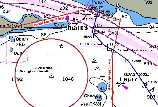
So we queried our instructions, and the controller was surprised to hear that we were heading for San Diego; evidently, they had been tracking us on radar, but not too carefully. He then told us to change course to "uh... let's see... one one -- uh, no, wait -- oh yeah, one one zero magnetic". Which was more or less the course we were originally on!
We set off again, and the boat that had intercepted us sped off busily. We continued monitoring channel 11, and were amused by plead control's halting attempts to give the patrol boat its next instructions; only to be told, by them, that those instructions were impossible!
As we motored off, channel 11 provided much amusement for hours to come. We heard the various boats, planes and land stations talking to each other, giving each other contradictory instructions, failing to answer direct questions, and generally acting like the Keystone Cops. Not too reassuring...
Wed 9 Apr 2003 11:11 US/Pacific
With some relief, given the state of confusion which seems to reign here, we exited the Pacific Missile Range. We're motoring along in very light wind; the good news is, it's warm out here!
There's no nearby traffic, though ships are visible in the traffic lane to the north.
Wed 9 Apr 2003 12:36 US/Pacific
We copied another broadcast on channel 16 confirming the position of the live-firing exercise as 33° 47' N, 119° 27' W -- the same as before. We had been wondering if we'd got it wrong, but evidently not.
Wed 9 Apr 2003 13:19 US/Pacific
Copied another broadcast on channel 16 giving the position of the live-firing exercise, but this time at 33° 49' N, 119° 12' W. No explanation was given of why it had changed. I tried to call plead control on channel 16 (the broadcast had said we could call them on 16) to confirm this new position, but got no response.
Once plotted, the new position did indeed include the location where we had been chased off, so that makes sense. What makes less sense is that the exclusion zone now includes some sea that isn't part of the missile range at all, and part of the main shipping lane. Are they planning to use freighters as targets?
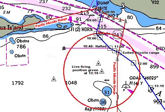
Of course, the fact that they had been broadcasting the position of a live missile-firing exercise to all mariners wrongly, all morning, is rather bad -- it wasn't corrected (if the new position is correct) until 2½ hours after we had been chased out.
Wed 9 Apr 2003 13:50 US/Pacific
Unbelievable -- we just copied yet another broadcast on channel 16, giving yet another position for the live-firing exercise, but this time at 33° 51' N, 119° 13' W. Again, no explanation was given of why it had changed. However, I contacted plead control on channel 11, and got this new position confirmed.
The new location includes even more of the shipping lane:
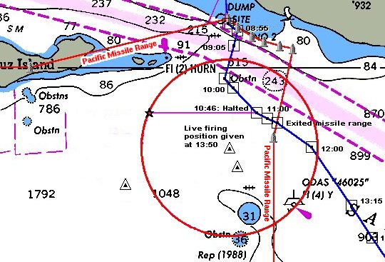
Meanwhile, the fiasco continues to unfold on VHF. A US Navy warship has been trying to get the attention of a fishing boat, which is apparently steaming right into the danger zone. Repeated calls on 16 haven't worked; the latest call said "This is the large warship steaming directly alongside of you to starboard...". Evidently, the guys on the fishing boat still haven't got the message.
Wed 9 Apr 2003 15:36 US/Pacific
We can now see Santa Catalina island off the port bow, and Santa Barbara (faintly in the haze) to starboard.
We finally got a bit of wind, and started sailing under main and genoa. In fact, we're making 5.7 knots!
Wed 9 Apr 2003 16:05 US/Pacific
It's clear and sunny except for a light haze, which is visible around the islands. Santa Catalina is looking very Mediterranean off our port bow. But where are those gamboling dolphins?
The wind has eased a little, and we're now making 4 knots. We can hear occasional loud "booms", presumably from the Navy firing exercise on San Clemente island, which is now to our south -- safely far away, we hope!
Wed 9 Apr 2003 18:10 US/Pacific
A while ago we heard a large vessel approaching from astern, slightly to starboard. It didn't seem to register on radar, so we thought it might be a Navy ship. We heard the rumble of the engines for 15 minutes before we could see it.
However, as the ship passed us, it turned out to be a Dole ship; we surmised it was loaded with Hawaiian pineapples. Probably it didn't show on radar because it was much farther off than we thought; the sound of its engines really seemed to carry over the water.
The wind has died to the point where we've lowered the sails and started motoring again.
Wed 9 Apr 2003 20:11 US/Pacific
Night has fallen, and some stars are coming through the overcast -- there's a half moon overhead, with a huge, complete halo about 22 degrees in radius. This is caused by light reflecting off ice crystals in the upper atmosphere.
We're on the last leg -- our course is straight from here, 76 miles to San Diego!
Wed 9 Apr 2003 23:00 US/Pacific
We're currently entering the main shipping channel that leads up to Los Angeles, so we're keeping a sharp lookout. We're tracking three ships on radar and visually, plotting their courses so we can keep well clear of them. One ship is coming up behind us to starboard, and two from the south, only one of which we can actually see.
Wed 9 Apr 2003 23:35 US/Pacific
Ship number two has been causing us severe headaches, since it's been impossible to figure out its course. Now we've figured out that it seems to be circling; it has steaming lights like a normal ship, but also a red flashing light.
Thu 10 Apr 2003 01:04 US/Pacific
The ship watch continues; we're now tracking ship 2, still behaving oddly but 7.5 miles astern to starboard, plus ships 4 and 5. We have a visual on number 4; it's 7 miles away to port, moving to our port, and we can see its port light, as well as its fore and aft steaming lights, well separated, so it looks like it's heading safely past us on a reciprocal course. Number 5 is dead ahead, 10 miles off, and seems to be heading north, so should pass us ahead. Its fore and aft steaming lights are visible distinct from each other.
Thu 10 Apr 2003 02:00 US/Pacific
Still tracking ships 2 and 5, but there's no other traffic about within 24 miles. Number 2 is now 7 miles astern to port, so it still seems to be circling, or following us, or something. Number 5 is 5 miles to port, and heading north, away from us.
The sky is clearing somewhat; there's no wind, but we're only 40 miles from San Diego!
Thu 10 Apr 2003 03:00 US/Pacific
Yet another ship, number 6, appeared 8 miles astern to port half an hour ago; it's now 4 miles away, crossing our stern southbound. Number 2 is still around, 9 miles astern, now to starboard.
Thu 10 Apr 2003 04:00 US/Pacific
Ship number 7 has made its entrance, 10 miles astern and to starboard. Good old number 2 is still there, now 6 miles abeam to starboard. Number 6 is also off to starboard, heading off.
This doesn't have the usual quality of solitude and the vast ocean to ourselves as a typical night watch! We feel as though the ocean's alive with big ships. Still, the sky is clear -- the moon has set, and there are lots of stars visible, even the Milky Way.
Thu 10 Apr 2003 05:00 US/Pacific
Ship number 2 is now 8 miles dead astern. What is it up to?
We can now see a bit of San Diego on the 24 mile radar! Specifically La Jolla, 21 miles away.
This doesn't have the usual quality of solitude and the vast ocean to ourselves as a typical night watch! We feel as though the ocean's alive with big ships. Still, the sky is clear -- the moon has set, and there are lots of stars visible, even the Milky Way.
Thu 10 Apr 2003 07:00 US/Pacific
Sky overcast but breaking up; the only traffic about is a sail to port, and something off the starboard bow -- looks like a fishing boat, just over 2 miles off on radar.
Land is just visible to port! Only 13.3 miles to San Diego.
Thu 10 Apr 2003 10:05 US/Pacific
We're just passing the first pair of San Diego buoys!
Thu 10 Apr 2003 10:57 US/Pacific
After making our way up the narrow entrance to San Diego Bay, and into the channel behind Shelter Island, we're finally docked -- at the police dock, San Diego.
Thu 10 Apr 2003 11:18 US/Pacific
We've decided to spend a few nights at the police dock marina here; after checking in, we got slip 17, and moved Moonrise around. We're here!