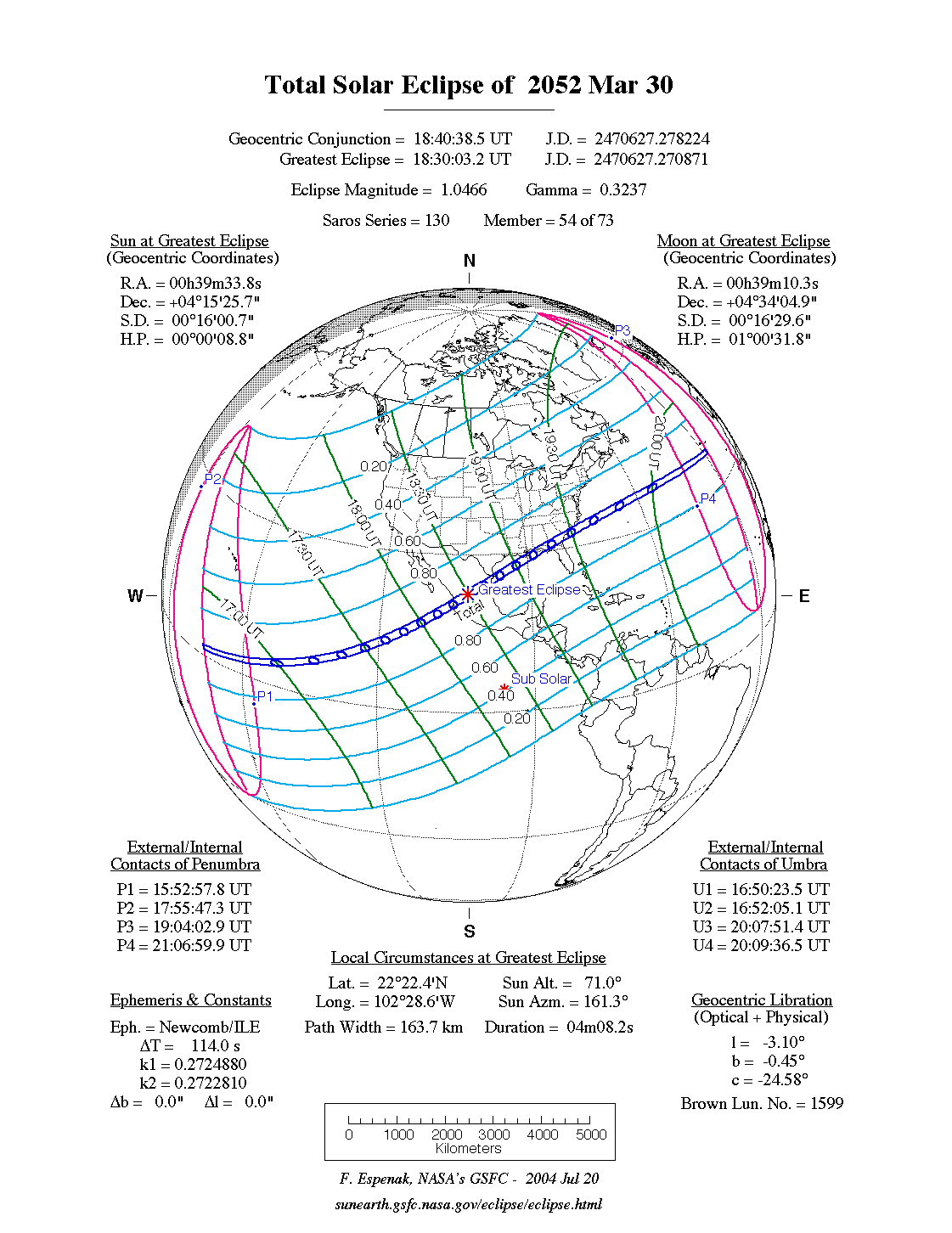
A total eclipse of the Sun occurs on Saturday 30 March, 2052 UT, lasting from 15:52–21:07 UT. A dramatic total eclipse will plunge the Sun into darkness for 4 minutes and 8 seconds at maximum, creating an amazing spectacle for observers in a broad path up to 164 km wide. It will be seen across Mexico and the south-eastern US. The partial eclipse will be visible across most of North America.
The timings of the phases of the overall eclipse
worldwide are as follows. In any particular
place it will be seen for a significantly shorter
duration as the shadow moves across the Earth:
| Partial eclipse begins: |
15:52:58 UT |
| Total eclipse begins: |
16:50:23 UT |
| Maximum eclipse: |
18:30:03 UT |
| Total eclipse ends: |
20:09:36 UT |
| Partial eclipse ends: |
21:07:00 UT |
During this eclipse the Sun will be 0.534° in apparent
diameter, around average. The Moon will be just a day before perigee, making it very large.
At the start and end of the eclipse the Moon
will be 0.549°, and at maximum eclipse 0.559°,
which is 5.2% larger than average; hence it will cover the Sun,
making this a total eclipse.
The statistics page has information on the ranges of the sizes of
the Sun and Moon, and the Moon data page displays detailed
information on the Moon's key dates.
Line Islands
The total eclipse begins at local dawn, 16:50 UT in the Christmas, or Line, Islands of the Pacific. As the Sun is rising, the centre of the total eclipse will pass over Kiribati, giving residents there a superb view; the eclipse will last 1 minute and 40 seconds, and will be visible over a path 105 km (65.2 miles) wide.
Mexico
After crossing the Pacific, the total eclipse will reach Mexico at Bahía Banderas and Puerto Vallarta at 18:21 UT. By now, the eclipse is approaching maximum, and the duration on the centreline will be 4 minutes and 6 seconds, and the path width will be 164 km (101.9 miles).
The centreline of the eclipse passes just north of Ixtlán at 18:24 UT, and continues north-east. The eclipse reaches its maximum just south-west of Ojocaliente, Zacatecas, at 18:30 UT, where it will last for 4 minutes and 8 seconds. The path of totality will be 164 km (101.9 miles) wide here. The total eclipse then passes just south of Matehuala at 18:36 UT.
The centre of the eclipse crosses the Laguna Madre to reach the Gulf of Mexico at 18:45 UT, just south of the US border; in fact, a little corner of Texas will be inside the path of the totality. However, it will be so close to the edge that it would be well worth travelling south into Mexico to get closer to the centre and see a longer eclipse, still over 4 minutes on the centreline.
USA
The centre of the total eclipse will cross the tip of the Mississippi Delta at 19:09 UT; although the eclipse is now waning, it will still last 3 minutes 51 seconds on the centreline, and be visible over a path 157 km (97.6 miles) wide. New Orleans will miss the excitement; but a short drive east into the Florida panhandle will make all the difference. The eclipse touches land there at 19:16 UT, with the centreline passing just south of Santa Rosa Beach, and then moves north-east to Lake Seminole; it passes over Altha, Fl, south-west of the lake, at 19:18 UT. This same spot saw a total eclipse just seven years previously on 12 August, 2045. The total eclipse here still lasts 3 minutes 41 seconds on the centreline, and the path is 154 km (95.7 miles) wide.
Finally, the eclipse crosses Georgia towards Savannah; the centreline passes just south of there at 19:27 UT, with the path being 151 km (93.8 miles) wide, so Savannah should get a good view. The eclipse will still last 3 minutes 30 seconds on the centreline. The bottom corner of South Carolina will be in the same boat, but anyone much farther north would be well advised to head south, as after this the eclipse heads out to sea, eventually finishing south of the Azores.
Interactive Map
This map shows the visibility of the eclipse.
The shaded area will see the total solar eclipse; however, near the edges of
this area, the eclipse will be very short. The bold line shows the centre
of the path, where the eclipse will last longest, so this is where you want to be if possible.
Use the zoom controls to zoom in and out; hover your mouse over any
point on the centreline to see the time and
duration of the eclipse at that point. You can pan and zoom the map to
see detail for any part of the eclipse path.
The interactive map is currently not available.
Overview Map
This map sourced from NASA Goddard Space flight Center: GSFC Eclipse Web SiteGSFC Eclipse Web Site
The primary source of all the information on eclipses presented here at Hermit Eclipse. (NASA Goddard Space flight Center)
shows the visibility of the total solar eclipse. It also shows the broader area in which a partial eclipse will be seen. (Click on it for the
full-sized version.)
Eclipse Season and Saros Series
This eclipse season contains 2 eclipses:
This is the 54th eclipse in solar Saros series 130.The surrounding eclipses in this Saros series are:
This Saros series, solar Saros series 130,
is linked to lunar Saros series 123. The
nearest partner eclipses in that series are:
Eclipse Parameters
| UT Date/time (max) | 18:30:16 on 30 Mar UT |
TDT Date/time (max) | 18:31:53 on 30 Mar TDT |
| Saros Series | 130 |
Number in Series | 54 |
| Penumbral Magnitiude | |
Central Magnitiude | 1.0466 |
| Gamma | 0.3238 |
Path Width (km) | 164 |
| Delta T | 1m37s |
Error | ± 0m32s (95%) |
| Penumbral Duration | |
Partial Duration | |
| Total Duration | 4m08s |
| |
| Partial Rating | |
Total Rating | |
| Sun Distance | 149427615 km (48.2%) |
Moon Distance | 362257 km (11.6%) |
| Sun Diameter | 0.534° |
Moon Diameter | 0.549° - 0.559° |
| Apogee | 04:37 on 20 Mar UT |
Perigee | 05:26 on 1 Apr UT |
| Contact p1 | 15:52:58 on 30 Mar UT |
Contact p2 | |
| Contact u1 | 16:50:23 on 30 Mar UT |
Contact u2 | 16:52:05 on 30 Mar UT |
| Max eclipse | 18:30:03 on 30 Mar UT |
| Contact u3 | 20:07:51 on 30 Mar UT |
Contact u4 | 20:09:36 on 30 Mar UT |
| Contact p3 | |
Contact p4 | 21:07:00 on 30 Mar UT |
Note that while all dates and times on this site (except
where noted) are in UT, which is within a second of civil time,
the dates and times shown in NASA's eclipse listingsGSFC Eclipse Web Site
The primary source of all the information on eclipses presented here at Hermit Eclipse. (NASA Goddard Space flight Center)
are in the TDT timescale.
The Sun and Moon distances are shown in km, and as a
percentage of their minimum - maximum distances; hence 0%
is the closest possible (Earth's perihelion, or the
Moon's closest possible perigee) and 100% is
the farthest (aphelion, the farthest apogee).
The statistics page has information on the ranges of sizes
of the Sun and Moon, and the Moon data page displays detailed
information on the Moon's key dates.
Data last updated: 2015-06-21 22:11:46 UTC.