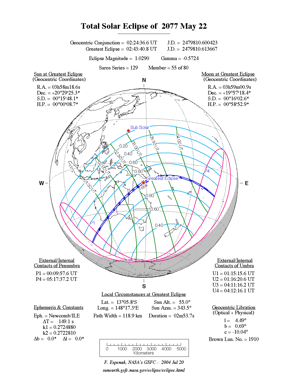
A total eclipse of the Sun occurs on Saturday 22 May, 2077 UT, lasting from 00:09–05:17 UT. A dramatic total eclipse will plunge the Sun into darkness for 2 minutes and 54 seconds at maximum, creating an amazing spectacle for observers in a path up to 119 km wide. It will be seen in Australia, the southern islands of Papua New Guinea, and the Solomon Islands. The partial eclipse will be visible across South Asia, Australia, and New Zealand.
The timings of the phases of the overall eclipse
worldwide are as follows. In any particular
place it will be seen for a significantly shorter
duration as the shadow moves across the Earth:
| Partial eclipse begins: |
00:09:58 UT |
| Total eclipse begins: |
01:15:16 UT |
| Maximum eclipse: |
02:43:41 UT |
| Total eclipse ends: |
04:12:16 UT |
| Partial eclipse ends: |
05:17:37 UT |
During this eclipse the Sun will be 0.527° in apparent
diameter, 1.2% smaller than average. The Moon will be just 3 days past perigee, making it relatively large.
At the start and end of the eclipse the Moon
will be 0.535°, and at maximum eclipse 0.542°,
which is 2.1% larger than average; hence it will cover the Sun,
making this a total eclipse.
The statistics page has information on the ranges of the sizes of
the Sun and Moon, and the Moon data page displays detailed
information on the Moon's key dates.
Australia
The eclipse begins in the Indian Ocean and makes landfall in south-western Australia at around 01:26–01:28 UT. The total eclipse will first be seen from Eclipse Island, appropriately — the island is named for Captain George Vancouver's observation of the total solar eclipse of 27 September, 1791, though he only witnessed a partial eclipse, albeit a very deep one. On this occasion, the island will see a total eclipse; but as it is on the very edge of the path it will only see about 34 seconds of totality. The island also saw the total eclipse of December 2066.
The centreline of the eclipse reaches land east of Hopetoun at 01:28 UT, where the duration will be 1 minute 45 seconds, and the path of totality will be a relatively narrow 84 km (52.2 miles) wide. After this it runs north-east, across the Dundas Nature Reserve; at 01:34 UT it passes north of Lake Boonderoo, where the total eclpse of May 2068 was seen, and at 01:41 UT it passes north-west of Wanna Lakes, where the eclipse of December 2038 was seen. The eclipse then crosses the north-west corner of South Australia at about 01:43–01:48 UT.
In the Northern Territory, at 01:51 UT, the eclipse passes south of Finke Gorge, an area which also saw the total eclipse of July 2037. It then passes right by Alice Springs around 01:55 UT; the town will see a total eclipse of 2 minutes 20 seconds, only a few seconds shorter than the duration on the centreline. At 02:01 UT, the eclipse passes through an area north-east of Dulcie Ranges National Park which also saw the total eclipse of July, 2028.
The eclipse enters Queensland at around 02:07 UT; Carpenteria will see the total eclipse at 02:14 UT, but only for 44 seconds, whereas on the centreline totality will last for 2 minutes 42 seconds. The path passes right over Staaten River National Park, and the Palmer River Goldfields Reserve at 02:28 UT; this area also witnessed the total eclipse of November 2012. The total eclipse finally reaches the coast north of Cooktown at around 02:32 UT. Close now to maximum, the eclipse will last close to 3 minutes on the centreline here.
Papua New Guinea
The path of totality passes between Misima Island and Sudest Island around 02:58–03:01 UT. Gulowa Island is on the centreline, and will see 2 minutes 51 seconds of total eclipse; Misima Isand will see between 1 minute 50 seconds and 2 minutes 34 seconds, the longest duration being in the south; and the north tip of Sudest Island will see just 1 minute 11 seconds of totality.
The Solomon Islands
The total eclipse grazes Nggatokae Island, but properly reaches the Solomons at Pavuvu Island, at 03:19 UT, where the total eclipse will last 2 minutes 38 seconds. Guadalcanal will see totality, but only for just over a minute at Honiara; the northern tip of the island is better off, with 2 minutes 16 seconds of totality. The eclipse passes over Malaita at about 03:24 UT, with the eclipse still over 2 and a half minutes on the centreline.
Tiny Sikaiana Atoll sees the total eclipse at 03:30 UT; after that, the eclipse runs out into the Pacific and ends at 04:12 UT.
Interactive Map
This map shows the visibility of the eclipse.
The shaded area will see the total solar eclipse; however, near the edges of
this area, the eclipse will be very short. The bold line shows the centre
of the path, where the eclipse will last longest, so this is where you want to be if possible.
Use the zoom controls to zoom in and out; hover your mouse over any
point on the centreline to see the time and
duration of the eclipse at that point. You can pan and zoom the map to
see detail for any part of the eclipse path.
The interactive map is currently not available.
Overview Map
This map sourced from NASA Goddard Space flight Center: GSFC Eclipse Web SiteGSFC Eclipse Web Site
The primary source of all the information on eclipses presented here at Hermit Eclipse. (NASA Goddard Space flight Center)
shows the visibility of the total solar eclipse. It also shows the broader area in which a partial eclipse will be seen. (Click on it for the
full-sized version.)
Eclipse Season and Saros Series
This eclipse season contains 2 eclipses:
This is the 55th eclipse in solar Saros series 129.The surrounding eclipses in this Saros series are:
This Saros series, solar Saros series 129,
is linked to lunar Saros series 122. The
nearest partner eclipses in that series are:
Eclipse Parameters
| UT Date/time (max) | 02:43:34 on 22 May UT |
TDT Date/time (max) | 02:46:05 on 22 May TDT |
| Saros Series | 129 |
Number in Series | 55 |
| Penumbral Magnitiude | |
Central Magnitiude | 1.029 |
| Gamma | -0.5725 |
Path Width (km) | 119 |
| Delta T | 2m31s |
Error | ± 1m01s (95%) |
| Penumbral Duration | |
Partial Duration | |
| Total Duration | 2m54s |
| |
| Partial Rating | |
Total Rating | |
| Sun Distance | 151423080 km (89.5%) |
Moon Distance | 372406 km (31.8%) |
| Sun Diameter | 0.527° |
Moon Diameter | 0.535° - 0.542° |
| Perigee | 20:00 on 18 May UT |
Apogee | 18:40 on 30 May UT |
| Contact p1 | 00:09:58 on 22 May UT |
Contact p2 | |
| Contact u1 | 01:15:16 on 22 May UT |
Contact u2 | 01:16:21 on 22 May UT |
| Max eclipse | 02:43:41 on 22 May UT |
| Contact u3 | 04:11:16 on 22 May UT |
Contact u4 | 04:12:16 on 22 May UT |
| Contact p3 | |
Contact p4 | 05:17:37 on 22 May UT |
Note that while all dates and times on this site (except
where noted) are in UT, which is within a second of civil time,
the dates and times shown in NASA's eclipse listingsGSFC Eclipse Web Site
The primary source of all the information on eclipses presented here at Hermit Eclipse. (NASA Goddard Space flight Center)
are in the TDT timescale.
The Sun and Moon distances are shown in km, and as a
percentage of their minimum - maximum distances; hence 0%
is the closest possible (Earth's perihelion, or the
Moon's closest possible perigee) and 100% is
the farthest (aphelion, the farthest apogee).
The statistics page has information on the ranges of sizes
of the Sun and Moon, and the Moon data page displays detailed
information on the Moon's key dates.
Data last updated: 2015-06-21 22:11:46 UTC.