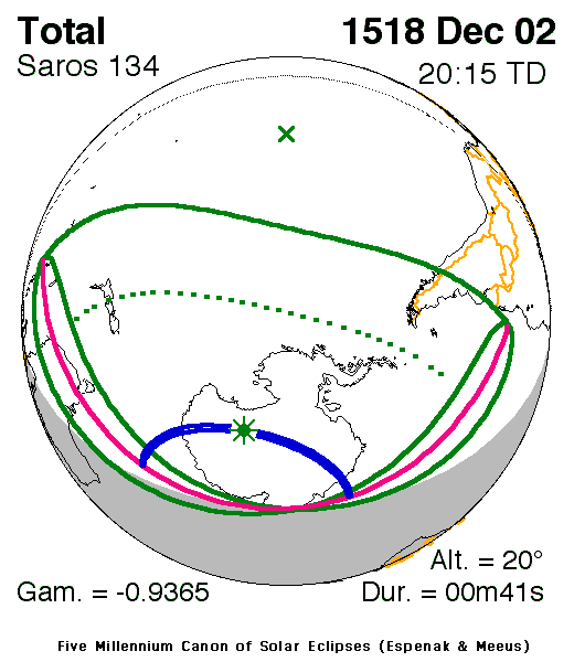
A total eclipse of the Sun occurred on 2 December, 1518 UT Old Style, with maximum eclipse at 20:12 UT. A fleeting total eclipse covered a path up to 125 km wide and lasted for 41 seconds at the point of maximum eclipse.
The total eclipse lasted for 41 seconds.
Maximum eclipse was at 20:12:01 UT.
Overview Map
This map sourced from NASA Goddard Space flight Center: GSFC Eclipse Web SiteGSFC Eclipse Web Site
The primary source of all the information on eclipses presented here at Hermit Eclipse. (NASA Goddard Space flight Center)
shows the visibility of the total solar eclipse. It also shows the broader area in which a partial eclipse was seen. (Click on it for the
full-sized version.)
Eclipse Season and Saros Series
This eclipse season contains 2 eclipses:
This was the 16th eclipse in solar Saros series 134.The surrounding eclipses in this Saros series are:
This Saros series, solar Saros series 134,
is linked to lunar Saros series 127. The
nearest partner eclipses in that series are:
Eclipse Parameters
| UT Date/time (max) | 20:12:01 on 2 Dec UT |
TDT Date/time (max) | 20:14:58 on 2 Dec TDT |
| Saros Series | 134 |
Number in Series | 16 |
| Penumbral Magnitiude | |
Central Magnitiude | 1.0124 |
| Gamma | -0.9365 |
Path Width (km) | 125 |
| Delta T | 2m57s |
Error | ± 0m39s (95%) |
| Penumbral Duration | |
Partial Duration | |
| Total Duration | 0m41s |
| |
| Partial Rating | |
Total Rating | |
Note that while all dates and times on this site (except
where noted) are in UT, which is within a second of civil time,
the dates and times shown in NASA's eclipse listingsGSFC Eclipse Web Site
The primary source of all the information on eclipses presented here at Hermit Eclipse. (NASA Goddard Space flight Center)
are in the TDT timescale.
Data last updated: 2015-06-21 22:11:45 UTC.