A partial eclipse of the Sun occurred on Thursday 23 October, 2014 UT, lasting from 19:37–23:51 UT. This was a deep partial eclipse, with 81% of the Sun covered for viewers closest to the center. This provided a significant spectacle for those who saw it over most of the USA (except the eastern side), western Canada, and Mexico.
The timings of the phases of the overall eclipse
worldwide are as follows. In any particular
place it would have been seen for a significantly shorter
duration as the shadow moved across the Earth:
| Partial eclipse began: |
19:37:33 UT |
| Maximum eclipse: |
21:44:32 UT |
| Partial eclipse ended: |
23:51:40 UT |
During this eclipse the Sun was 0.536° in apparent
diameter, 0.5% larger than average. The Moon was 5 days after apogee and 10 days before perigee.
At maximum eclipse it was 0.508° in apparent
diameter, which is 4.3% smaller than average. This has no real
effect on this eclipse, since the Moon's central
shadow misses the Earth, making this a partial eclipse.
The statistics page has information on the ranges of the sizes of
the Sun and Moon, and the Moon data page displays detailed
information on the Moon's key dates.
Sunspot Flash!
A gigantic sunspot cluster, AR 2192, was crossing the Sun's face during the eclipse. This was visible during the eclipse (and before and after it, for that matter), with proper safe observing techniques; even just looking through eclipse glasses, it was quite visible.
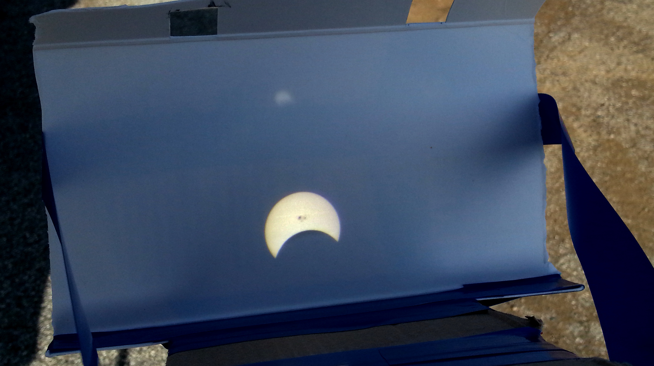
The eclipse just after maximum in Palo Alto, CA; photographed in a simple Sun projector. Note that the image is upside-down. Active Region 2192 is clearly visible. The
observing page has information on making a projector like this.
Viewing
The partial eclipse will be visible in the Russian Far Eastern Federal District and most of North America, excepting the north-east. In eastern regions the eclipse will be happening at sunset, so a clear view of the horizon is required, and the full eclipse may not be visible depending on where you are. As always, a clear sky is essential, so check the weather and head for where there's the least chance of clouds.

The eclipse coverage, based on the
NASA eclipse dataGSFC Eclipse Web Site
The primary source of all the information on eclipses presented here at Hermit Eclipse. (NASA Goddard Space flight Center)
.
Russia
The partial eclipse wil begin over eastern Siberia and the Kamchatka Peninsula at sunrise. Most of Magadan Oblast, the eastern end of the Sakha Republic, and western Chukotka will see the sun rise after maximum eclipse; most of Chukotka and most of Kamchatka will see the sun rise before maximum, which will occur around 20:30 UT. Eastern Chukotka will see the entire eclipse, with the maximum around 20:50 UT.
Alaska, Canada
The greatest eclipse will be seen in extreme northern Canada, where the Sun wil be seen 80% covered. In Alaska except for the south-west, an eclipse of over 60% will be seen, with the maximum eclipse ocurring between 21:00 UT in the west and 21:30 UT in the south-east. Most of Canada will also see a 60% or greater eclipse, with the maximum around 22:00 UT across Alberta, and shortly later in Saskatchewan. In Manitoba and western Ontario, the Sun will set after maximum eclipse, so the whole eclipse will not be visible; in eastern Ontario and western Quebec, only the earlier stages of the eclipse will be visible before sunset, and farther west, it will not be seen at all.
Lower 48, North
In the lower US, a 60% or greater eclipse will be seen in Washington state, northern Oregon, Idaho north of the Snake river, Montana, northern Wyoming, the Dakotas, Minnesota, and northern Wisconsin. In Washington, maximum eclipse occurs at 22:00 UT; in South Dakota and northern Minnesota it comes at 22:30 UT. From the Dakotas east, the sun will be setting during the eclipse, and from Michigan east, it will set before maximum eclipse. The far north-eastern states will struggle to see any eclipse at all.
Lower 48, South
Farther south, a 40% eclipse or more will be visible in California and the south-western US states, including northern Texas, Oklahoma, Arkansas, northern Mississippi, and northern Alabama. San Francisco will see the Sun close to 50% obscured at around 22:15 UT; likewise most of Nevada, Utah, Colorado, and Kansas, as well as points north, can look forward to a 50% or greater eclipse.
From Kansas, Oklahoma and eastern Texas eastwards, the Sun will set during the eclipse; and from Florida, Georgia and Ohio eastwards, it will set before maximum eclipse. Louisville, KY, will see maximum eclipse almost exactly at sunset — for those with a clear view to the horizon.
Sample Timings
The following table summarises the circumstances at various places; "Coverage" is the percentage of the Sun's diameter which will be covered at maximum eclipse:
| Place | Start | Maximum | Coverage | End |
|---|
| Petropavlovsk, KAM | sunrise | 20:21 UT | 19% | 21:04 UT |
| Bilibino, CHU | sunrise | 20:43 UT | 52% | 21:46 UT |
| Anadyr, CHU | 19:41 UT | 20:44 UT | 51% | 21:50 UT |
| Egvekinot, CHU | 19:43 UT | 20:48 UT | 55% | 21:56 UT |
| Lavrentiya, CHU | 19:45 UT | 20:53 UT | 58% | 22:03 UT |
| Anchorage, AK | 19:54 UT | 21:10 UT | 64% | 22:28 UT |
| Juneau, AK | 20:09 UT | 21:30 UT | 69% | 22:50 UT |
| Tuktoyaktuk, NT | 20:09 UT | 21:24 UT | 76% | 22:38 UT |
| Vancouver, BC | 20:31 UT | 21:56 UT | 65% | 23:16 UT |
| Calgary, AB | 20:43 UT | 22:05 UT | 70% | 23:22 UT |
| Winnipeg, MB | 21:08 UT | 22:23 UT | 69% | sunset |
| Seattle, WA | 20:35 UT | 22:00 UT | 64% | 23:19 UT |
| San Francisco, CA | 20:51 UT | 22:15 UT | 50% | 23:31 UT |
| San Diego, CA | 21:14 UT | 22:32 UT | 43% | 23:41 UT |
| Salt Lake City, UT | 21:04 UT | 22:25 UT | 57% | 23:38 UT |
| Billings, MT | 21:00 UT | 22:21 UT | 64% | 23:34 UT |
| Albuquerque, NM | 21:27 UT | 22:41 UT | 47% | 23:47 UT |
| Sunspot, NM | 21:34 UT | 22:45 UT | 43% | 23:49 UT |
| Minneapolis, MN | 21:23 UT | 22:35 UT | 61% | sunset |
| Houston, TX | 21:58 UT | 22:58 UT | 34% | sunset |
| Louisville, KY | 21:46 UT | 22:49 UT | 48% | sunset |
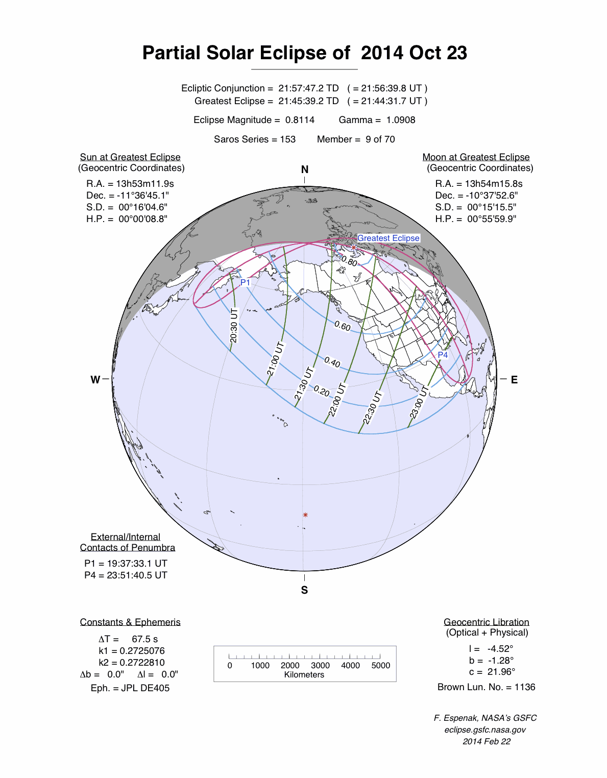
Overview Map
This map sourced from NASA Goddard Space flight Center: GSFC Eclipse Web SiteGSFC Eclipse Web Site
The primary source of all the information on eclipses presented here at Hermit Eclipse. (NASA Goddard Space flight Center)
shows the visibility of the partial solar eclipse. (Click on it for the
full-sized version.)
Eclipse Season and Saros Series
This eclipse season contains 2 eclipses:
This was the 9th eclipse in solar Saros series 153.The surrounding eclipses in this Saros series are:
This Saros series, solar Saros series 153,
is linked to lunar Saros series 146. The
nearest partner eclipses in that series are:
Eclipse Parameters
| UT Date/time (max) | 21:44:30 on 23 Oct UT |
TDT Date/time (max) | 21:45:39 on 23 Oct TDT |
| Saros Series | 153 |
Number in Series | 9 |
| Penumbral Magnitiude | |
Central Magnitiude | 0.8114 |
| Gamma | 1.0908 |
Path Width (km) | 0 |
| Delta T | 1m09s |
Error | ± 0m02s (95%) |
| Penumbral Duration | |
Partial Duration | |
| Total Duration | |
| |
| Partial Rating | |
Total Rating | |
| Sun Distance | 148828454 km (35.9%) |
Moon Distance | 391571 km (69.9%) |
| Sun Diameter | 0.536° |
Moon Diameter | 0.508° - 0.508° |
| Apogee | 06:06 on 18 Oct UT |
Perigee | 00:22 on 3 Nov UT |
| Contact p1 | 19:37:33 on 23 Oct UT |
Contact p2 | |
| Contact u1 | |
Contact u2 | |
| Max eclipse | 21:44:32 on 23 Oct UT |
| Contact u3 | |
Contact u4 | |
| Contact p3 | |
Contact p4 | 23:51:40 on 23 Oct UT |
Note that while all dates and times on this site (except
where noted) are in UT, which is within a second of civil time,
the dates and times shown in NASA's eclipse listingsGSFC Eclipse Web Site
The primary source of all the information on eclipses presented here at Hermit Eclipse. (NASA Goddard Space flight Center)
are in the TDT timescale.
The Sun and Moon distances are shown in km, and as a
percentage of their minimum - maximum distances; hence 0%
is the closest possible (Earth's perihelion, or the
Moon's closest possible perigee) and 100% is
the farthest (aphelion, the farthest apogee).
The statistics page has information on the ranges of sizes
of the Sun and Moon, and the Moon data page displays detailed
information on the Moon's key dates.
Data last updated: 2015-06-21 22:11:46 UTC.