An annular eclipse of the Sun occurred on Thursday 1 September, 2016 UT, lasting from 06:13–12:00 UT. A large annular eclipse covered 97% of the Sun, creating a dramatic spectacle for observers in a path up to 100 km wide; it lasted 3 minutes and 6 seconds at the point of maximum eclipse. It was seen across central Africa southwards to Madagascar and into the Indian Ocean. The partial eclipse was visible across most of Africa and parts of the Middle East.
The timings of the phases of the overall eclipse
worldwide are as follows. In any particular
place it would have been seen for a significantly shorter
duration as the shadow moved across the Earth:
| Partial eclipse began: |
06:13:08 UT |
| Annular eclipse began: |
07:17:50 UT |
| Maximum eclipse: |
09:06:54 UT |
| Annular eclipse ended: |
10:55:54 UT |
| Partial eclipse ended: |
12:00:40 UT |
During this eclipse the Sun was 0.528° in apparent
diameter, 0.9% smaller than average. The Moon was 10 days after perigee and 5 days before apogee.
At maximum eclipse it was 0.514° in
apparent diameter, which is 3.1% smaller than average; this was not
large enough to cover the Sun, which is why this
was an annular eclipse.
The statistics page has information on the ranges of the sizes of
the Sun and Moon, and the Moon data page displays detailed
information on the Moon's key dates.
West Africa
The eclipse arrives in Gabon at 07:39 UT, at which point the annular phase will last 2 minutes 52 seconds, and will be visible over a path 124 km (77.1 miles) wide. The eclipse then moves off over Congo and the Dem. Rep. of Congo, arriving in Tanzania at 08:35 UT over Lake Tanganyika; by this time the duration of the annular phase will be up to 3 minutes and 4 seconds.
East Africa
The eclipse path crosses south-east over Tanzania, where the maximum eclipse of 3 minutes and 6 seconds will occur at 09:06 UT. It then crosses into Mozambique, arriving there at 09:11 UT, and into the sea at 09:19 UT.
Madagascar, Mascarene Islands
The annular eclipse arrives at Madagascar at 09:39 UT, where the duration of the annular phase will still be over 3 minutes, and the annular eclipse will be visible over a path 101 km (62.8 miles) wide. It crosses Madagascar south-east, reaching the sea again at 09:51 UT.
Finally, most of Réunion will see the annular eclipse at about 10:09 UT. Although the island is not on the centreline, the duration in the south-west should be quite good, as the centreline duration is still over 3 minutes.
Interactive Map
This map shows the visibility of the eclipse.
The shaded area saw the annular solar eclipse; however, near the edges of
this area, the eclipse was very short. The bold line shows the centre
of the path, where the eclipse lasted longest.
Use the zoom controls to zoom in and out; hover your mouse over any
point on the centreline to see the time and
duration of the eclipse at that point. You can pan and zoom the map to
see detail for any part of the eclipse path.
The interactive map is currently not available.
Overview Map
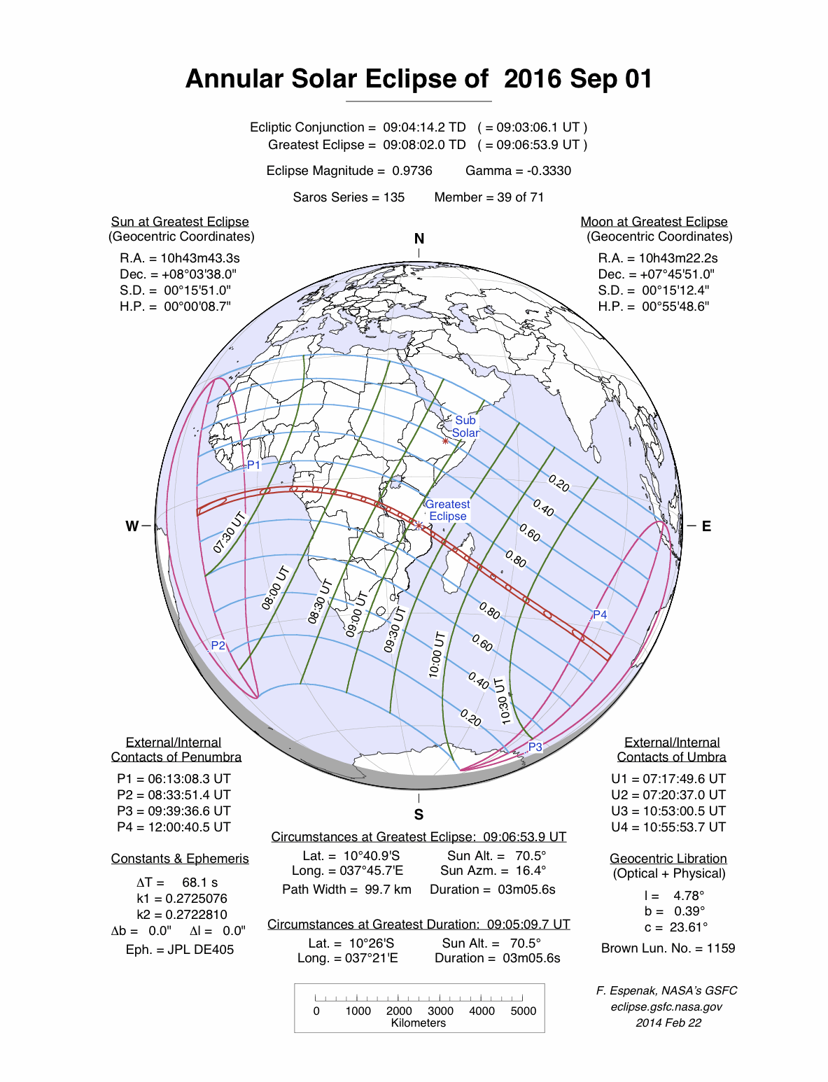
This map sourced from NASA Goddard Space flight Center: GSFC Eclipse Web SiteGSFC Eclipse Web Site
The primary source of all the information on eclipses presented here at Hermit Eclipse. (NASA Goddard Space flight Center)
shows the visibility of the annular solar eclipse. It also shows the broader area in which a partial eclipse was seen. (Click on it for the
full-sized version.)
Eclipse Season and Saros Series
This eclipse season contains 2 eclipses:
This was the 39th eclipse in solar Saros series 135.The surrounding eclipses in this Saros series are:
This Saros series, solar Saros series 135,
is linked to lunar Saros series 128. The
nearest partner eclipses in that series are:
Eclipse Parameters
| UT Date/time (max) | 09:06:52 on 1 Sep UT |
TDT Date/time (max) | 09:08:02 on 1 Sep TDT |
| Saros Series | 135 |
Number in Series | 39 |
| Penumbral Magnitiude | |
Central Magnitiude | 0.9736 |
| Gamma | -0.333 |
Path Width (km) | 100 |
| Delta T | 1m10s |
Error | ± 0m03s (95%) |
| Penumbral Duration | |
Partial Duration | |
| Total Duration | 3m06s |
| |
| Partial Rating | major |
Total Rating | major |
| Sun Distance | 150962892 km (80.0%) |
Moon Distance | 392909 km (72.6%) |
| Sun Diameter | 0.528° |
Moon Diameter | 0.507° - 0.514° |
| Perigee | 01:21 on 22 Aug UT |
Apogee | 18:45 on 6 Sep UT |
| Contact p1 | 06:13:08 on 1 Sep UT |
Contact p2 | |
| Contact u1 | 07:17:50 on 1 Sep UT |
Contact u2 | 07:20:37 on 1 Sep UT |
| Max eclipse | 09:06:54 on 1 Sep UT |
| Contact u3 | 10:53:00 on 1 Sep UT |
Contact u4 | 10:55:54 on 1 Sep UT |
| Contact p3 | |
Contact p4 | 12:00:40 on 1 Sep UT |
Note that while all dates and times on this site (except
where noted) are in UT, which is within a second of civil time,
the dates and times shown in NASA's eclipse listingsGSFC Eclipse Web Site
The primary source of all the information on eclipses presented here at Hermit Eclipse. (NASA Goddard Space flight Center)
are in the TDT timescale.
The Sun and Moon distances are shown in km, and as a
percentage of their minimum - maximum distances; hence 0%
is the closest possible (Earth's perihelion, or the
Moon's closest possible perigee) and 100% is
the farthest (aphelion, the farthest apogee).
The statistics page has information on the ranges of sizes
of the Sun and Moon, and the Moon data page displays detailed
information on the Moon's key dates.
Data last updated: 2015-06-21 22:11:46 UTC.