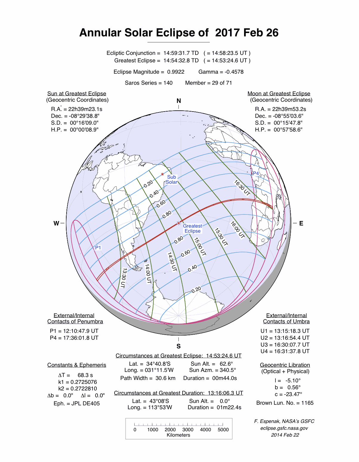
An annular eclipse of the Sun occurred on Sunday 26 February, 2017 UT, lasting from 12:10–17:36 UT. A large annular eclipse covered over 99% of the Sun, creating a dramatic spectacle for observers in a narrow path at most 31 km wide; it lasted 44 seconds at the point of maximum eclipse. It was seen from southern South America, across the Atlantic, and into southern Africa. The partial eclipse was visible in southern South America, and south-west Africa.
The timings of the phases of the overall eclipse
worldwide are as follows. In any particular
place it would have been seen for a significantly shorter
duration as the shadow moved across the Earth:
| Partial eclipse began: |
12:10:48 UT |
| Annular eclipse began: |
13:15:18 UT |
| Maximum eclipse: |
14:53:25 UT |
| Annular eclipse ended: |
16:31:38 UT |
| Partial eclipse ended: |
17:36:02 UT |
During this eclipse the Sun was 0.538° in apparent
diameter, 1.0% larger than average. The Moon was just 4 days before perigee, making it relatively large.
At maximum eclipse it was 0.534° in
apparent diameter, which is 0.6% larger than average; this was not
large enough to cover the Sun, which is why this
was an annular eclipse.
The statistics page has information on the ranges of the sizes of
the Sun and Moon, and the Moon data page displays detailed
information on the Moon's key dates.
South America
The eclipse crosses Chile and Argentina between 13:34 UT and 13:44 UT. The path width is shrinking from 58 km (36 miles) to 50 km (31.1 miles) as the eclipse builds, and the duration of the annular phase is just over 1 minute.
Africa
The eclipse reaches Africa in Angola at 16:26 UT; it is reaching the end of the annular eclipse, with a duration of 1 minute 9 seconds, and a path width of 73 km (45.4 miles). The eclipse crosses the northern tip of Zambia and ends in the Democratic Republic of Congo at 16:30 UT.
Interactive Map
This map shows the visibility of the eclipse.
The shaded area saw the annular solar eclipse; however, near the edges of
this area, the eclipse was very short. The bold line shows the centre
of the path, where the eclipse lasted longest.
Use the zoom controls to zoom in and out; hover your mouse over any
point on the centreline to see the time and
duration of the eclipse at that point. You can pan and zoom the map to
see detail for any part of the eclipse path.
The interactive map is currently not available.
Overview Map
This map sourced from NASA Goddard Space flight Center: GSFC Eclipse Web SiteGSFC Eclipse Web Site
The primary source of all the information on eclipses presented here at Hermit Eclipse. (NASA Goddard Space flight Center)
shows the visibility of the annular solar eclipse. It also shows the broader area in which a partial eclipse was seen. (Click on it for the
full-sized version.)
Eclipse Season and Saros Series
This eclipse season contains 2 eclipses:
This was the 29th eclipse in solar Saros series 140.The surrounding eclipses in this Saros series are:
This Saros series, solar Saros series 140,
is linked to lunar Saros series 133. The
nearest partner eclipses in that series are:
Eclipse Parameters
| UT Date/time (max) | 14:53:23 on 26 Feb UT |
TDT Date/time (max) | 14:54:33 on 26 Feb TDT |
| Saros Series | 140 |
Number in Series | 29 |
| Penumbral Magnitiude | |
Central Magnitiude | 0.9922 |
| Gamma | -0.4578 |
Path Width (km) | 31 |
| Delta T | 1m10s |
Error | ± 0m04s (95%) |
| Penumbral Duration | |
Partial Duration | |
| Total Duration | 0m44s |
| |
| Partial Rating | major |
Total Rating | travel |
| Sun Distance | 148143744 km (21.7%) |
Moon Distance | 378213 km (43.4%) |
| Sun Diameter | 0.538° |
Moon Diameter | 0.526° - 0.534° |
| Apogee | 21:15 on 18 Feb UT |
Perigee | 07:25 on 3 Mar UT |
| Contact p1 | 12:10:48 on 26 Feb UT |
Contact p2 | |
| Contact u1 | 13:15:18 on 26 Feb UT |
Contact u2 | 13:16:54 on 26 Feb UT |
| Max eclipse | 14:53:25 on 26 Feb UT |
| Contact u3 | 16:30:08 on 26 Feb UT |
Contact u4 | 16:31:38 on 26 Feb UT |
| Contact p3 | |
Contact p4 | 17:36:02 on 26 Feb UT |
Note that while all dates and times on this site (except
where noted) are in UT, which is within a second of civil time,
the dates and times shown in NASA's eclipse listingsGSFC Eclipse Web Site
The primary source of all the information on eclipses presented here at Hermit Eclipse. (NASA Goddard Space flight Center)
are in the TDT timescale.
The Sun and Moon distances are shown in km, and as a
percentage of their minimum - maximum distances; hence 0%
is the closest possible (Earth's perihelion, or the
Moon's closest possible perigee) and 100% is
the farthest (aphelion, the farthest apogee).
The statistics page has information on the ranges of sizes
of the Sun and Moon, and the Moon data page displays detailed
information on the Moon's key dates.
Data last updated: 2015-06-21 22:11:46 UTC.