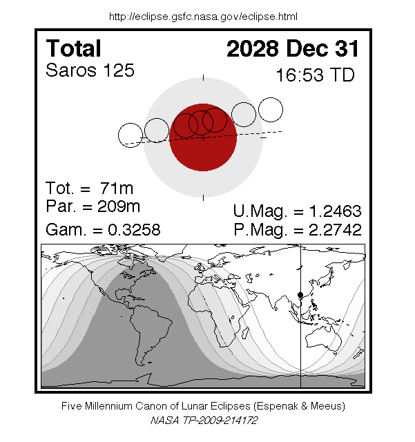
A total eclipse of the Moon occurs on Sunday 31 December, 2028 UT, lasting from 14:03–19:40 UT. The Moon will be plunged into darkness for 1 hour and 11 minutes, in a deep total eclipse which will see the Moon 25% of its diameter inside the Earth's umbral shadow. The visual effect of this depends on the state of the Earth's atmosphere, but the Moon may be stained a deep red colour for observers in north-east Africa, Europe, Asia, Australia, north-western Canada, and Alaska. The partial eclipse will last for 3 hours and 29 minutes in total.
The timings of the phases of the eclipse are as
follows. You will be able to see each phase of the
eclipse if the Moon is up at the corresponding time as
seen from your location; however the penumbral phase
will be very difficult to see in practice, so you may want to start watching at the partial phase:
| Penumbral eclipse begins: |
14:03:49 UT |
| Partial eclipse begins: |
15:07:35 UT |
| Total eclipse begins: |
16:16:19 UT |
| Maximum eclipse: |
16:51:58 UT |
| Total eclipse ends: |
17:27:40 UT |
| Partial eclipse ends: |
18:36:24 UT |
| Penumbral eclipse ends: |
19:40:02 UT |
During this eclipse the Moon will be just 4 days before perigee, making it relatively large.
At maximum eclipse it will be 0.536° in apparent
diameter, which is 1.0% larger than average.
The statistics page has information on the ranges of the sizes of
the Sun and Moon, and the Moon data page displays detailed
information on the Moon's key dates.
Interactive Map
This map shows the visibility of the eclipse at various stages.
The bright area in the middle will see the whole eclipse; the coloured
bands to the right will see the start of the eclipse, and those on the
left will see the end. Note that the map is approximate, and if you are
near the edge of the area of visibility, the moon will be very close to the
horizon and may not be practically visible.
You can use the zoom controls to zoom in and out, and pan to
see areas of interest. Hover your mouse over the
tags to see what will be visible from each area on the map. The green
marker in the centre shows where the Moon will be directly
overhead at maximum eclipse.
The interactive map is currently not available.
Overview Map
This map sourced from NASA Goddard Space flight Center: GSFC Eclipse Web SiteGSFC Eclipse Web Site
The primary source of all the information on eclipses presented here at Hermit Eclipse. (NASA Goddard Space flight Center)
shows the visibility of the eclipse. (Click on it for the
full-sized version.)
Eclipse Season and Saros Series
This eclipse season contains 2 eclipses:
This is the 49th eclipse in lunar Saros series 125.The surrounding eclipses in this Saros series are:
This Saros series, lunar Saros series 125,
is linked to solar Saros series 132. The
nearest partner eclipses in that series are:
Eclipse Parameters
| UT Date/time (max) | 16:51:58 on 31 Dec UT |
TDT Date/time (max) | 16:53:15 on 31 Dec TDT |
| Saros Series | 125 |
Number in Series | 49 |
| Penumbral Magnitiude | 2.2742 |
Central Magnitiude | 1.2463 |
| Gamma | 0.3258 |
Path Width (km) | |
| Delta T | 1m17s |
Error | ± 0m11s (95%) |
| Penumbral Duration | 5h36m |
Partial Duration | 3h29m |
| Total Duration | 1h11m |
| |
| Partial Rating | |
Total Rating | |
| Sun Distance | 147100383 km (0.1%) |
Moon Distance | 377589 km (42.1%) |
| Sun Diameter | 0.542° |
Moon Diameter | 0.527° - 0.536° |
| Apogee | 21:01 on 23 Dec UT |
Perigee | 04:17 on 5 Jan UT |
| Contact p1 | 14:03:49 on 31 Dec UT |
Contact p2 | |
| Contact u1 | 15:07:35 on 31 Dec UT |
Contact u2 | 16:16:19 on 31 Dec UT |
| Max eclipse | 16:51:58 on 31 Dec UT |
| Contact u3 | 17:27:40 on 31 Dec UT |
Contact u4 | 18:36:24 on 31 Dec UT |
| Contact p3 | |
Contact p4 | 19:40:02 on 31 Dec UT |
Note that while all dates and times on this site (except
where noted) are in UT, which is within a second of civil time,
the dates and times shown in NASA's eclipse listingsGSFC Eclipse Web Site
The primary source of all the information on eclipses presented here at Hermit Eclipse. (NASA Goddard Space flight Center)
are in the TDT timescale.
The Sun and Moon distances are shown in km, and as a
percentage of their minimum - maximum distances; hence 0%
is the closest possible (Earth's perihelion, or the
Moon's closest possible perigee) and 100% is
the farthest (aphelion, the farthest apogee).
The statistics page has information on the ranges of sizes
of the Sun and Moon, and the Moon data page displays detailed
information on the Moon's key dates.
Data last updated: 2015-06-21 22:11:46 UTC.