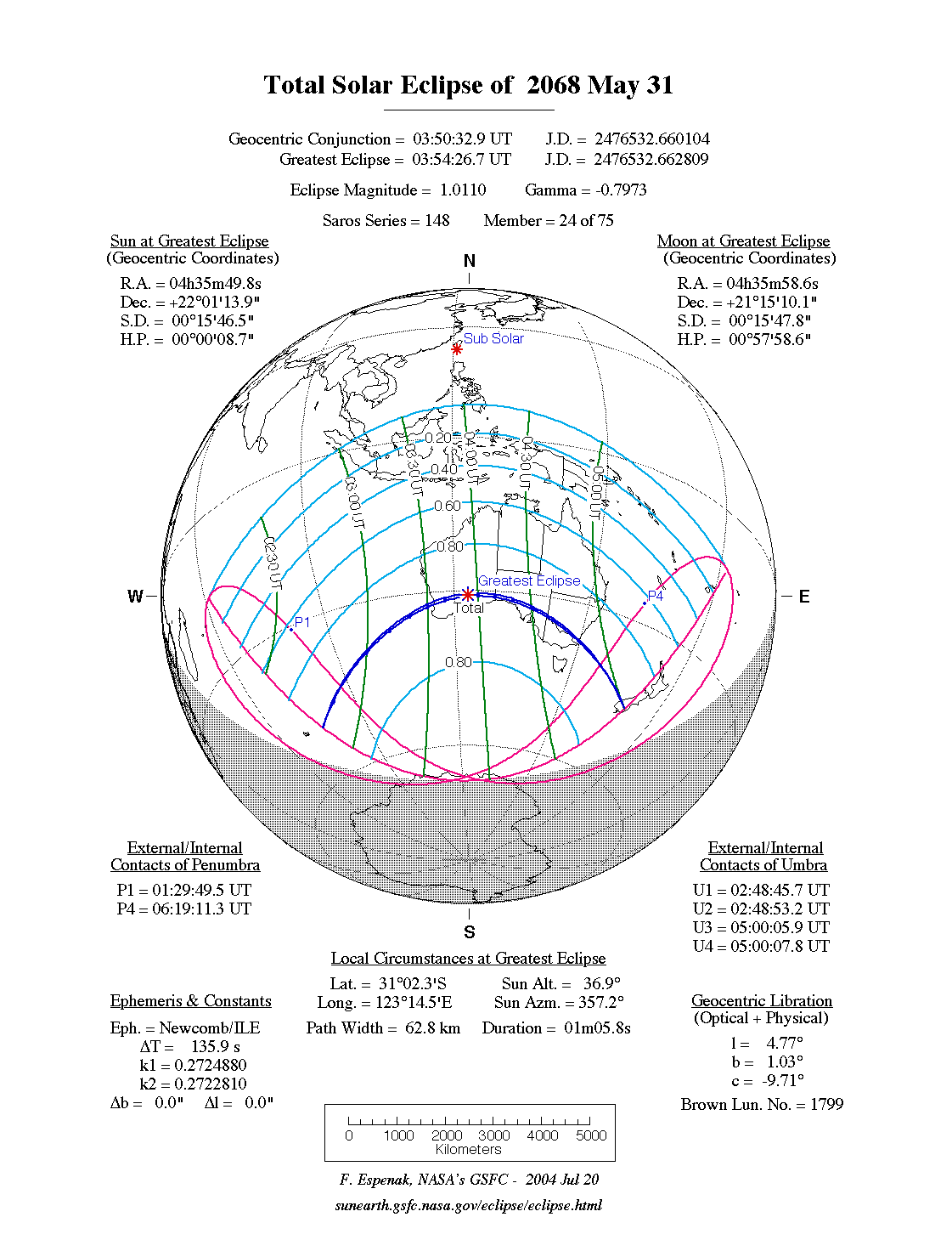
A total eclipse of the Sun occurs on Thursday 31 May, 2068 UT, lasting from 01:29–06:19 UT. The Sun will be darkened for 1 minute and 6 seconds by a dramatic total eclipse covering a narrow path at most 63 km wide. This will be a sight worth seeing, and will be visible across the south of Australia and the South Island of New Zealand. The partial eclipse will be visible in Australia, New Zealand, and south Asia.
The timings of the phases of the overall eclipse
worldwide are as follows. In any particular
place it will be seen for a significantly shorter
duration as the shadow moves across the Earth:
| Partial eclipse begins: |
01:29:49 UT |
| Total eclipse begins: |
02:48:46 UT |
| Maximum eclipse: |
03:54:27 UT |
| Total eclipse ends: |
05:00:08 UT |
| Partial eclipse ends: |
06:19:11 UT |
During this eclipse the Sun will be 0.526° in apparent
diameter, 1.3% smaller than average. The Moon will be 5 days after perigee and 8 days before apogee.
At the start and end of the eclipse the Moon
will be 0.526°, and at maximum eclipse 0.532°,
which is around average; hence it will cover the Sun,
making this a total eclipse.
The statistics page has information on the ranges of the sizes of
the Sun and Moon, and the Moon data page displays detailed
information on the Moon's key dates.
Australia
The eclipse begins just east of Kerguelen, in the Indian Ocean, and crosses the ocean to make landfall in Australia at Rockingham, south of Perth, at around 03:34 UT. The total eclipse here will last just over a minute; with the path being only 59 km (36.7 miles) wide, most of Perth will not see a total eclipse.
The eclipse passes over Wandoo National Park and over southern Western Australia, missing Kalgoorlie but passing over the north shore of Lake Lefroy at about 03:50 UT. Here the total eclipse will last 1 minute 5 seconds on the centreline; maximum eclipse is just 4 minutes later. At 03:58 UT the eclipse passes north of Lake Boonderoo, where the total eclpse of May 2077 will be seen.
The eclipse crosses into Nullarbor National Park in South Australia at about 04:10 UT, then crosses Spencer Gulf just south of Port Augusta at about 04:31 UT. Port Augusta is close to the north edge of the path and will see only 33 seconds of total eclipse, compared to 50 on the centreline. At 04:23 UT the eclipse passes through an area of the Pureba Conservation Park north-east of Ceduna; this area saw a total solar eclipse in 2002, and it also joins the path of the December 2038 eclipse. Minutes later the eclipse passes by the south end of Lake Gairdner, where the eclipse of November 2030 was visible. Just minutes later again, at 04:35 UT, the eclipse passes west of Danggali Conservation Park, where the eclipse of 2093 will be seen.
The eclipse enters New South Wales at about 04:37 UT, passing north of Mildura a couple of minutes later; it passes right over Jindabyne at 04:49 UT, where the total eclipse will last just 30 seconds. It reaches the sea at Pambula at 04:50 UT.
New Zealand
In its very last stages, the total eclipse reaches New Zealand's South Island at Sutherland Sound at around 05:00 UT; here the total eclipse will last just over 3 seconds on the centreline, and it will be seen from a path just a few km (miles) wide; this area also saw the total eclipse of July 2028. The last gasp of the eclipse streaks across the island and ends at sunset, just seconds later, shortly before reaching the coast.
Interactive Map
This map shows the visibility of the eclipse.
The shaded area will see the total solar eclipse; however, near the edges of
this area, the eclipse will be very short. The bold line shows the centre
of the path, where the eclipse will last longest, so this is where you want to be if possible.
Use the zoom controls to zoom in and out; hover your mouse over any
point on the centreline to see the time and
duration of the eclipse at that point. You can pan and zoom the map to
see detail for any part of the eclipse path.
The interactive map is currently not available.
Overview Map
This map sourced from NASA Goddard Space flight Center: GSFC Eclipse Web SiteGSFC Eclipse Web Site
The primary source of all the information on eclipses presented here at Hermit Eclipse. (NASA Goddard Space flight Center)
shows the visibility of the total solar eclipse. It also shows the broader area in which a partial eclipse will be seen. (Click on it for the
full-sized version.)
Eclipse Season and Saros Series
This eclipse season contains 2 eclipses:
This is the 24th eclipse in solar Saros series 148.The surrounding eclipses in this Saros series are:
This Saros series, solar Saros series 148,
is linked to lunar Saros series 141. The
nearest partner eclipses in that series are:
Eclipse Parameters
| UT Date/time (max) | 03:54:28 on 31 May UT |
TDT Date/time (max) | 03:56:39 on 31 May TDT |
| Saros Series | 148 |
Number in Series | 24 |
| Penumbral Magnitiude | |
Central Magnitiude | 1.011 |
| Gamma | -0.797 |
Path Width (km) | 63 |
| Delta T | 2m11s |
Error | ± 0m50s (95%) |
| Penumbral Duration | |
Partial Duration | |
| Total Duration | 1m06s |
| |
| Partial Rating | |
Total Rating | |
| Sun Distance | 151673212 km (94.7%) |
Moon Distance | 378215 km (43.4%) |
| Sun Diameter | 0.526° |
Moon Diameter | 0.526° - 0.532° |
| Perigee | 09:18 on 26 May UT |
Apogee | 22:06 on 7 Jun UT |
| Contact p1 | 01:29:49 on 31 May UT |
Contact p2 | |
| Contact u1 | 02:48:46 on 31 May UT |
Contact u2 | 02:48:53 on 31 May UT |
| Max eclipse | 03:54:27 on 31 May UT |
| Contact u3 | 05:00:06 on 31 May UT |
Contact u4 | 05:00:08 on 31 May UT |
| Contact p3 | |
Contact p4 | 06:19:11 on 31 May UT |
Note that while all dates and times on this site (except
where noted) are in UT, which is within a second of civil time,
the dates and times shown in NASA's eclipse listingsGSFC Eclipse Web Site
The primary source of all the information on eclipses presented here at Hermit Eclipse. (NASA Goddard Space flight Center)
are in the TDT timescale.
The Sun and Moon distances are shown in km, and as a
percentage of their minimum - maximum distances; hence 0%
is the closest possible (Earth's perihelion, or the
Moon's closest possible perigee) and 100% is
the farthest (aphelion, the farthest apogee).
The statistics page has information on the ranges of sizes
of the Sun and Moon, and the Moon data page displays detailed
information on the Moon's key dates.
Data last updated: 2015-06-21 22:11:46 UTC.