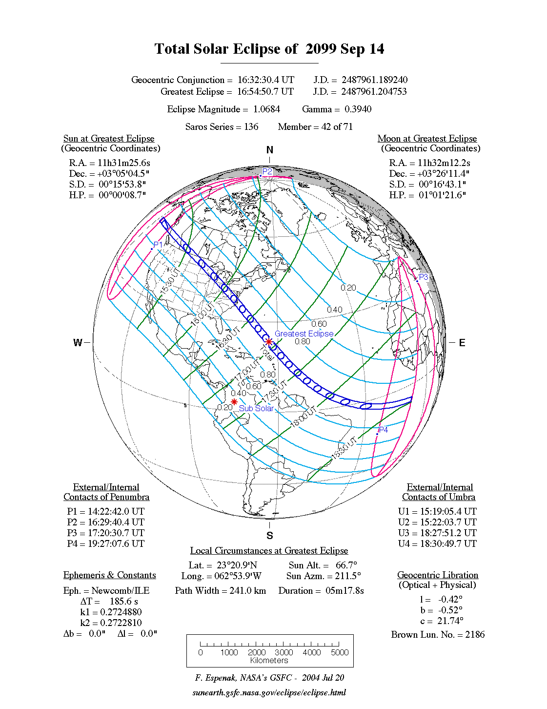
A total eclipse of the Sun occurs on Monday 14 September, 2099 UT, lasting from 14:22–19:27 UT. A dramatic total eclipse will plunge the Sun into darkness for 5 minutes and 18 seconds at maximum, creating an amazing spectacle for observers in a very broad path, 241 km wide at maximum. It will be seen across south-west Canada and the US. The partial eclipse will be visible in most of the Americas and western Africa.
The timings of the phases of the overall eclipse
worldwide are as follows. In any particular
place it will be seen for a significantly shorter
duration as the shadow moves across the Earth:
| Partial eclipse begins: |
14:22:42 UT |
| Total eclipse begins: |
15:19:05 UT |
| Maximum eclipse: |
16:54:51 UT |
| Total eclipse ends: |
18:30:50 UT |
| Partial eclipse ends: |
19:27:08 UT |
During this eclipse the Sun will be 0.530° in apparent
diameter, 0.6% smaller than average. The Moon will be at perigee, making it extremely large.
At the start and end of the eclipse the Moon
will be 0.557°, and at maximum eclipse 0.566°,
which is 6.6% larger than average; hence it will cover the Sun,
making this a total eclipse.
The statistics page has information on the ranges of the sizes of
the Sun and Moon, and the Moon data page displays detailed
information on the Moon's key dates.
The total eclipse will begin just off the Pacific coast of Canada, then cross north America from British Columbia, through Alberta, Saskatchewan, North Dakota, Minnesota, Wisconsin, Ohio, the Virginias, and North Carolina.
Interactive Map
This map shows the visibility of the eclipse.
The shaded area will see the total solar eclipse; however, near the edges of
this area, the eclipse will be very short. The bold line shows the centre
of the path, where the eclipse will last longest, so this is where you want to be if possible.
Use the zoom controls to zoom in and out; hover your mouse over any
point on the centreline to see the time and
duration of the eclipse at that point. You can pan and zoom the map to
see detail for any part of the eclipse path.
The interactive map is currently not available.
Overview Map
This map sourced from NASA Goddard Space flight Center: GSFC Eclipse Web SiteGSFC Eclipse Web Site
The primary source of all the information on eclipses presented here at Hermit Eclipse. (NASA Goddard Space flight Center)
shows the visibility of the total solar eclipse. It also shows the broader area in which a partial eclipse will be seen. (Click on it for the
full-sized version.)
Eclipse Season and Saros Series
This eclipse season contains 2 eclipses:
This is the 42nd eclipse in solar Saros series 136.The surrounding eclipses in this Saros series are:
This Saros series, solar Saros series 136,
is linked to lunar Saros series 129. The
nearest partner eclipses in that series are:
Eclipse Parameters
| UT Date/time (max) | 16:54:31 on 14 Sep UT |
TDT Date/time (max) | 16:57:53 on 14 Sep TDT |
| Saros Series | 136 |
Number in Series | 42 |
| Penumbral Magnitiude | |
Central Magnitiude | 1.0684 |
| Gamma | 0.3942 |
Path Width (km) | 241 |
| Delta T | 3m22s |
Error | ± 1m32s (95%) |
| Penumbral Duration | |
Partial Duration | |
| Total Duration | 5m18s |
| |
| Partial Rating | |
Total Rating | |
| Sun Distance | 150516168 km (70.8%) |
Moon Distance | 357360 km (1.9%) |
| Sun Diameter | 0.530° |
Moon Diameter | 0.557° - 0.566° |
| Apogee | 19:48 on 1 Sep UT |
Perigee | 23:29 on 14 Sep UT |
| Contact p1 | 14:22:42 on 14 Sep UT |
Contact p2 | |
| Contact u1 | 15:19:05 on 14 Sep UT |
Contact u2 | 15:22:04 on 14 Sep UT |
| Max eclipse | 16:54:51 on 14 Sep UT |
| Contact u3 | 18:27:51 on 14 Sep UT |
Contact u4 | 18:30:50 on 14 Sep UT |
| Contact p3 | |
Contact p4 | 19:27:08 on 14 Sep UT |
Note that while all dates and times on this site (except
where noted) are in UT, which is within a second of civil time,
the dates and times shown in NASA's eclipse listingsGSFC Eclipse Web Site
The primary source of all the information on eclipses presented here at Hermit Eclipse. (NASA Goddard Space flight Center)
are in the TDT timescale.
The Sun and Moon distances are shown in km, and as a
percentage of their minimum - maximum distances; hence 0%
is the closest possible (Earth's perihelion, or the
Moon's closest possible perigee) and 100% is
the farthest (aphelion, the farthest apogee).
The statistics page has information on the ranges of sizes
of the Sun and Moon, and the Moon data page displays detailed
information on the Moon's key dates.
Data last updated: 2015-06-21 22:11:46 UTC.