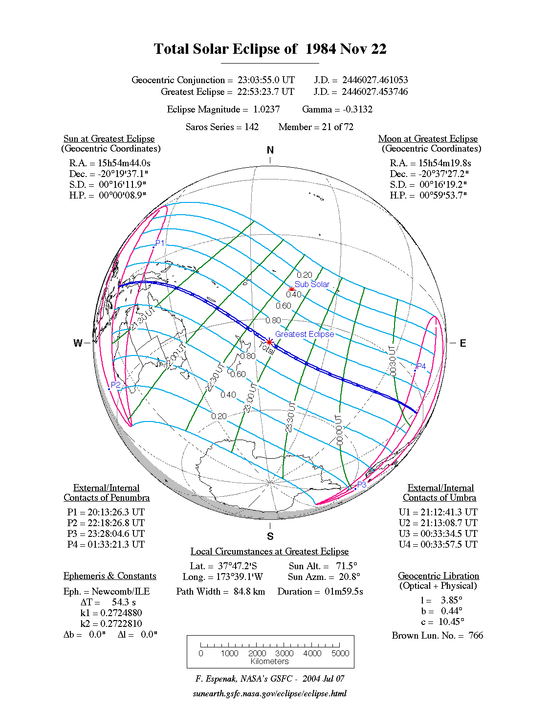
A total eclipse of the Sun occurred on Thursday 22 November, 1984 UT, with maximum eclipse at 22:53 UT. A dramatic total eclipse plunged the Sun into darkness for 2 minutes exactly at maximum, creating an amazing spectacle for observers in a path up to 85 km wide.
The total eclipse lasted for 2 minutes exactly.
Maximum eclipse was at 22:53:23 UT.
During this eclipse the Sun was 0.540° in apparent
diameter, 1.3% larger than average. The Moon was just 2 days past perigee, making it fairly large.
At the start and end of the eclipse the Moon
was 0.544°, and at maximum eclipse 0.553°,
which is 4.1% larger than average; hence it covered the Sun,
making this a total eclipse.
The statistics page has information on the ranges of the sizes of
the Sun and Moon, and the Moon data page displays detailed
information on the Moon's key dates.
Interactive Map
This map shows the visibility of the eclipse.
The shaded area saw the total solar eclipse; however, near the edges of
this area, the eclipse was very short. The bold line shows the centre
of the path, where the eclipse lasted longest.
Use the zoom controls to zoom in and out; hover your mouse over any
point on the centreline to see the time and
duration of the eclipse at that point. You can pan and zoom the map to
see detail for any part of the eclipse path.
The interactive map is currently not available.
Overview Map
This map sourced from NASA Goddard Space flight Center: GSFC Eclipse Web SiteGSFC Eclipse Web Site
The primary source of all the information on eclipses presented here at Hermit Eclipse. (NASA Goddard Space flight Center)
shows the visibility of the total solar eclipse. It also shows the broader area in which a partial eclipse was seen. (Click on it for the
full-sized version.)
Eclipse Season and Saros Series
This eclipse season contains 2 eclipses:
This was the 21st eclipse in solar Saros series 142.The surrounding eclipses in this Saros series are:
This Saros series, solar Saros series 142,
is linked to lunar Saros series 135. The
nearest partner eclipses in that series are:
Eclipse Parameters
| UT Date/time (max) | 22:53:23 on 22 Nov UT |
TDT Date/time (max) | 22:54:17 on 22 Nov TDT |
| Saros Series | 142 |
Number in Series | 21 |
| Penumbral Magnitiude | |
Central Magnitiude | 1.0237 |
| Gamma | -0.3132 |
Path Width (km) | 85 |
| Delta T | 0m54s |
Error | ± 0m00s (95%) |
| Penumbral Duration | |
Partial Duration | |
| Total Duration | 2m00s |
| |
| Partial Rating | |
Total Rating | |
| Sun Distance | 147716345 km (12.9%) |
Moon Distance | 366098 km (19.3%) |
| Sun Diameter | 0.540° |
Moon Diameter | 0.544° - 0.553° |
| Perigee | 20:54 on 20 Nov UT |
Apogee | 15:26 on 2 Dec UT |
Note that while all dates and times on this site (except
where noted) are in UT, which is within a second of civil time,
the dates and times shown in NASA's eclipse listingsGSFC Eclipse Web Site
The primary source of all the information on eclipses presented here at Hermit Eclipse. (NASA Goddard Space flight Center)
are in the TDT timescale.
The Sun and Moon distances are shown in km, and as a
percentage of their minimum - maximum distances; hence 0%
is the closest possible (Earth's perihelion, or the
Moon's closest possible perigee) and 100% is
the farthest (aphelion, the farthest apogee).
The statistics page has information on the ranges of sizes
of the Sun and Moon, and the Moon data page displays detailed
information on the Moon's key dates.
Data last updated: 2015-06-21 22:11:46 UTC.