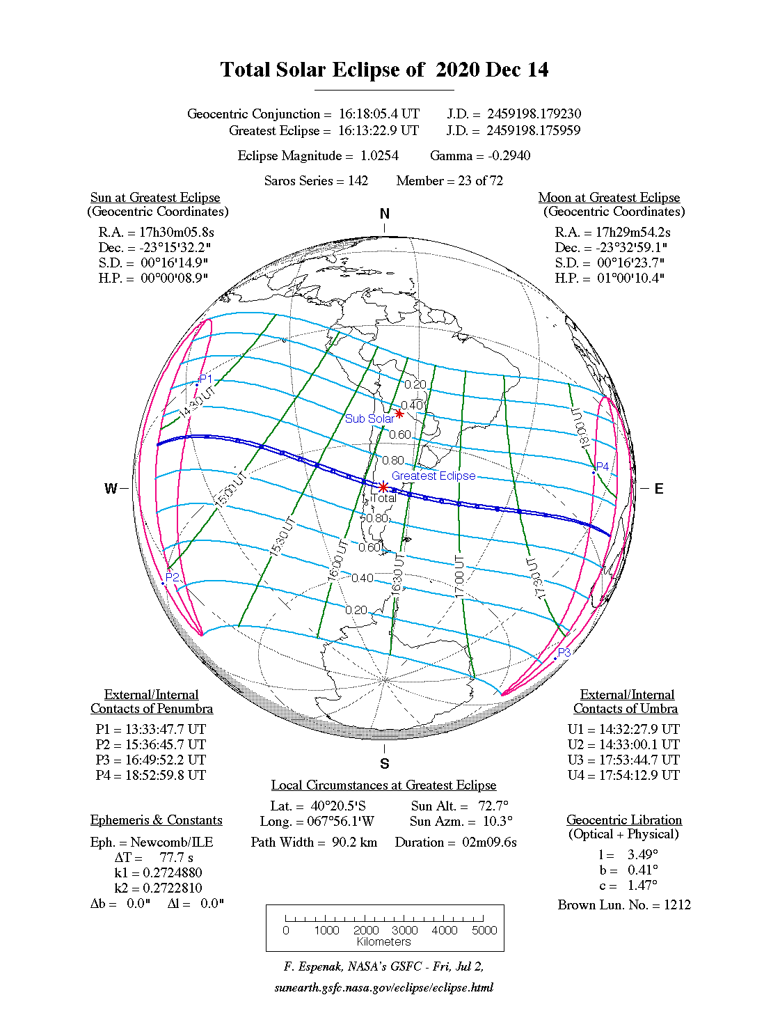
A total eclipse of the Sun occurred on Monday 14 December, 2020 UT, lasting from 13:33–18:53 UT. A dramatic total eclipse plunged the Sun into darkness for 2 minutes and 10 seconds at maximum, creating an amazing spectacle for observers in a path up to 90 km wide. It was seen from the Pacific to the Atlantic via Chile and Argentina. The partial eclipse was visible over southern South America.
The timings of the phases of the overall eclipse
worldwide are as follows. In any particular
place it would have been seen for a significantly shorter
duration as the shadow moved across the Earth:
| Partial eclipse began: |
13:33:48 UT |
| Total eclipse began: |
14:32:28 UT |
| Maximum eclipse: |
16:13:23 UT |
| Total eclipse ended: |
17:54:13 UT |
| Partial eclipse ended: |
18:53:00 UT |
During this eclipse the Sun was 0.542° in apparent
diameter, 1.6% larger than average. The Moon was just 2 days past perigee, making it fairly large.
At the start and end of the eclipse the Moon
was 0.546°, and at maximum eclipse 0.555°,
which is 4.6% larger than average; hence it covered the Sun,
making this a total eclipse.
The statistics page has information on the ranges of the sizes of
the Sun and Moon, and the Moon data page displays detailed
information on the Moon's key dates.
The Pacific
The eclipse begins east of the Marquesas islands, and passes well north of Easter Island and south of the Juan Fernandez islands before reaching South America.
Chile, Argentina
The total eclipse reaches Chile at 16:01 UT, the centreline of the total eclipse making landfall just south of Punto Saavedra. The path is 90 km (55.9 miles) wide here, and the eclipse will last 2 minutes and 8 seconds on the centreline. In fact, the eclipse duration is at least this long for the whole of its time on land.
The eclipse moves south-east over Gorbea and Villarrica, and reaches the Argentina border at 16:05 UT. It crosses the country and reaches maximum eclipse at 16:13 UT; at this point, the total eclipse will last 2 minutes 9 seconds on the centreline, and will be visible over a path 90 km (55.9 miles) wide.
The total eclipse passes Valcheta about 16:18 UT; 2 minutes later it reaches the Golfo San Matías, just south of San Antonio Oeste. The centreline of the eclipse touches land again around Moron, and finally heads into open ocean about 16:24 UT. It then heads off over the Atlantic towards Africa, but ends before it reaches land.
Interactive Map
This map shows the visibility of the eclipse.
The shaded area saw the total solar eclipse; however, near the edges of
this area, the eclipse was very short. The bold line shows the centre
of the path, where the eclipse lasted longest.
Use the zoom controls to zoom in and out; hover your mouse over any
point on the centreline to see the time and
duration of the eclipse at that point. You can pan and zoom the map to
see detail for any part of the eclipse path.
The interactive map is currently not available.
Overview Map
This map sourced from NASA Goddard Space flight Center: GSFC Eclipse Web SiteGSFC Eclipse Web Site
The primary source of all the information on eclipses presented here at Hermit Eclipse. (NASA Goddard Space flight Center)
shows the visibility of the total solar eclipse. It also shows the broader area in which a partial eclipse was seen. (Click on it for the
full-sized version.)
Eclipse Season and Saros Series
This eclipse season contains 2 eclipses:
This was the 23rd eclipse in solar Saros series 142.The surrounding eclipses in this Saros series are:
This Saros series, solar Saros series 142,
is linked to lunar Saros series 135. The
nearest partner eclipses in that series are:
Eclipse Parameters
| UT Date/time (max) | 16:13:27 on 14 Dec UT |
TDT Date/time (max) | 16:14:39 on 14 Dec TDT |
| Saros Series | 142 |
Number in Series | 23 |
| Penumbral Magnitiude | |
Central Magnitiude | 1.0254 |
| Gamma | -0.2939 |
Path Width (km) | 90 |
| Delta T | 1m12s |
Error | ± 0m05s (95%) |
| Penumbral Duration | |
Partial Duration | |
| Total Duration | 2m10s |
| |
| Partial Rating | minor |
Total Rating | travel |
| Sun Distance | 147249284 km (3.2%) |
Moon Distance | 364408 km (15.9%) |
| Sun Diameter | 0.542° |
Moon Diameter | 0.546° - 0.555° |
| Perigee | 20:43 on 12 Dec UT |
Apogee | 16:33 on 24 Dec UT |
| Contact p1 | 13:33:48 on 14 Dec UT |
Contact p2 | |
| Contact u1 | 14:32:28 on 14 Dec UT |
Contact u2 | 14:33:00 on 14 Dec UT |
| Max eclipse | 16:13:23 on 14 Dec UT |
| Contact u3 | 17:53:45 on 14 Dec UT |
Contact u4 | 17:54:13 on 14 Dec UT |
| Contact p3 | |
Contact p4 | 18:53:00 on 14 Dec UT |
Note that while all dates and times on this site (except
where noted) are in UT, which is within a second of civil time,
the dates and times shown in NASA's eclipse listingsGSFC Eclipse Web Site
The primary source of all the information on eclipses presented here at Hermit Eclipse. (NASA Goddard Space flight Center)
are in the TDT timescale.
The Sun and Moon distances are shown in km, and as a
percentage of their minimum - maximum distances; hence 0%
is the closest possible (Earth's perihelion, or the
Moon's closest possible perigee) and 100% is
the farthest (aphelion, the farthest apogee).
The statistics page has information on the ranges of sizes
of the Sun and Moon, and the Moon data page displays detailed
information on the Moon's key dates.
Data last updated: 2015-06-21 22:11:46 UTC.