We have a
special site for this eclipse!
A detailed look at the total solar eclipse of March 9, 2016, with detailed path descriptions and viewing circumstances.
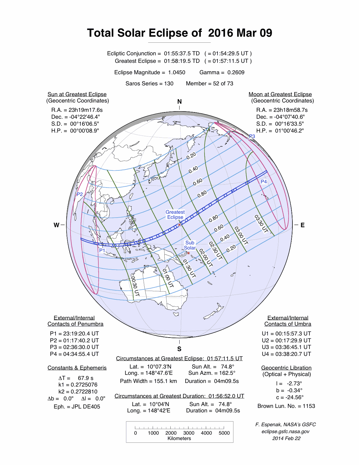
A total eclipse of the Sun occurred on Wednesday 9 March, 2016 UT, lasting from 23:19 on 8 Mar–04:34 UT. A dramatic total eclipse plunged the Sun into darkness for 4 minutes and 9 seconds at maximum, creating an amazing spectacle for observers in a path up to 155 km wide. It was seen from the Indian Ocean into the Pacific, across Indonesia. The partial eclipse was visible in South-east Asia and north and west Australia.
The timings of the phases of the overall eclipse
worldwide are as follows. In any particular
place it would have been seen for a significantly shorter
duration as the shadow moved across the Earth:
| Partial eclipse began: |
23:19:20 on 8 Mar UT |
| Total eclipse began: |
00:15:57 UT |
| Maximum eclipse: |
01:57:11 UT |
| Total eclipse ended: |
03:38:21 UT |
| Partial eclipse ended: |
04:34:55 UT |
During this eclipse the Sun was 0.537° in apparent
diameter, 0.7% larger than average. The Moon was just a day before perigee, making it very large.
At the start and end of the eclipse the Moon
was 0.552°, and at maximum eclipse 0.561°,
which is 5.7% larger than average; hence it covered the Sun,
making this a total eclipse.
The statistics page has information on the ranges of the sizes of
the Sun and Moon, and the Moon data page displays detailed
information on the Moon's key dates.
Sumatra, Borneo
The path of totality crosses Sumatra, passing just north of Palembang at 00:22 UT; Palembang will see a total eclipse lasting around 1 minute 50 seconds. The eclipse duration on the centreline is 2 minutes 4 seconds here, with the total eclipse visible over a path 114 km (70.8 miles) wide.
The total eclipse crosses over to Kalimantan; Sampit, south of the centreline, will see an eclipse lasting 2 minutes 8 seconds peaking at 00:29 UT; the duration on the centreline will be 2 minutes 27 seconds. The path curves slightly north as it passes east across Kalimantan, crossing the coast again around Tanangrogot at about 00:33 UT.
Sulawesi, Moluccas
The path of the total eclipse reaches Sulawesi at about Lariang at 00:38 UT, with the total eclipse now lasting 2 minutes 49 seconds on the centreline and visible across a path 134 km (83.3 miles) wide. It then runs along the coast from Ampoa to Maliku; Poso will see 2 minutes 40 seconds of total eclipse.
The path of totality reaches Halmahera in the Moluccas at Moti and Makian islands at 00:53 UT, with totality lasting 3 minutes 17 seconds on the centreline; the total eclipse should be visible to most of Halmahera.
The Pacific
After that, the path of the eclipse passes over Fani Island, which is towards the endge of the path of totality, and then heads off into open ocean. The centre of the elcipse passes virtually over Woleai Atoll at 01:40 UT, where the duration will be 4 minutes and 5 seconds; Wake Island is just outside the path of totality, but will see a partial eclipse covering 99.5% of the Sun peaking at 02:51 UT. The eclipse finally ends north-east of Hawaii at 03:38 UT.
Interactive Map
This map shows the visibility of the eclipse.
The shaded area saw the total solar eclipse; however, near the edges of
this area, the eclipse was very short. The bold line shows the centre
of the path, where the eclipse lasted longest.
Use the zoom controls to zoom in and out; hover your mouse over any
point on the centreline to see the time and
duration of the eclipse at that point. You can pan and zoom the map to
see detail for any part of the eclipse path.
The interactive map is currently not available.
Overview Map
This map sourced from NASA Goddard Space flight Center: GSFC Eclipse Web SiteGSFC Eclipse Web Site
The primary source of all the information on eclipses presented here at Hermit Eclipse. (NASA Goddard Space flight Center)
shows the visibility of the total solar eclipse. It also shows the broader area in which a partial eclipse was seen. (Click on it for the
full-sized version.)
Eclipse Season and Saros Series
This eclipse season contains 2 eclipses:
This was the 52nd eclipse in solar Saros series 130.The surrounding eclipses in this Saros series are:
This Saros series, solar Saros series 130,
is linked to lunar Saros series 123. The
nearest partner eclipses in that series are:
Eclipse Parameters
| UT Date/time (max) | 01:57:09 on 9 Mar UT |
TDT Date/time (max) | 01:58:19 on 9 Mar TDT |
| Saros Series | 130 |
Number in Series | 52 |
| Penumbral Magnitiude | |
Central Magnitiude | 1.045 |
| Gamma | 0.2609 |
Path Width (km) | 155 |
| Delta T | 1m10s |
Error | ± 0m03s (95%) |
| Penumbral Duration | |
Partial Duration | |
| Total Duration | 4m09s |
| |
| Partial Rating | major |
Total Rating | major |
| Sun Distance | 148541538 km (29.9%) |
Moon Distance | 360826 km (8.8%) |
| Sun Diameter | 0.537° |
Moon Diameter | 0.552° - 0.561° |
| Apogee | 03:28 on 27 Feb UT |
Perigee | 07:02 on 10 Mar UT |
| Contact p1 | 23:19:20 on 8 Mar UT |
Contact p2 | |
| Contact u1 | 00:15:57 on 9 Mar UT |
Contact u2 | 00:17:30 on 9 Mar UT |
| Max eclipse | 01:57:11 on 9 Mar UT |
| Contact u3 | 03:36:45 on 9 Mar UT |
Contact u4 | 03:38:21 on 9 Mar UT |
| Contact p3 | |
Contact p4 | 04:34:55 on 9 Mar UT |
Note that while all dates and times on this site (except
where noted) are in UT, which is within a second of civil time,
the dates and times shown in NASA's eclipse listingsGSFC Eclipse Web Site
The primary source of all the information on eclipses presented here at Hermit Eclipse. (NASA Goddard Space flight Center)
are in the TDT timescale.
The Sun and Moon distances are shown in km, and as a
percentage of their minimum - maximum distances; hence 0%
is the closest possible (Earth's perihelion, or the
Moon's closest possible perigee) and 100% is
the farthest (aphelion, the farthest apogee).
The statistics page has information on the ranges of sizes
of the Sun and Moon, and the Moon data page displays detailed
information on the Moon's key dates.
Data last updated: 2015-06-21 22:11:46 UTC.