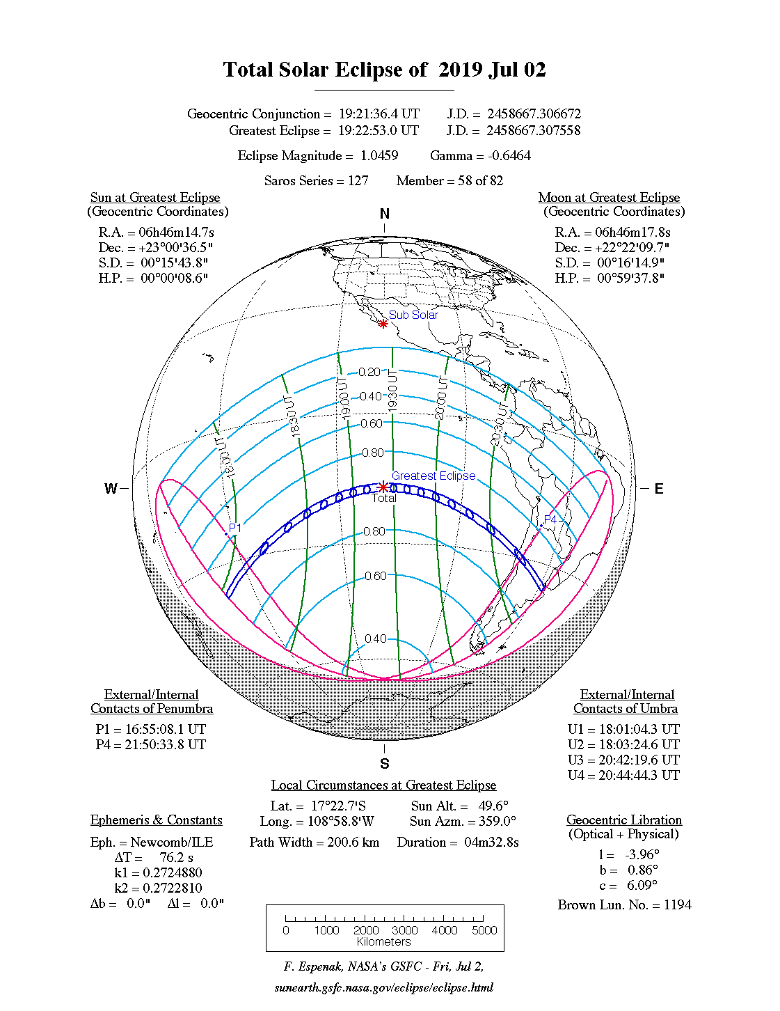
A total eclipse of the Sun occurred on Tuesday 2 July, 2019 UT, lasting from 16:55–21:50 UT. A dramatic total eclipse plunged the Sun into darkness for 4 minutes and 33 seconds at maximum, creating an amazing spectacle for observers in a broad path up to 201 km wide. It was seen across the south Pacific and over Chile and Argentina. The partial eclipse was visible in most of South America.
The timings of the phases of the overall eclipse
worldwide are as follows. In any particular
place it would have been seen for a significantly shorter
duration as the shadow moved across the Earth:
| Partial eclipse began: |
16:55:08 UT |
| Total eclipse began: |
18:01:04 UT |
| Maximum eclipse: |
19:22:53 UT |
| Total eclipse ended: |
20:44:44 UT |
| Partial eclipse ended: |
21:50:34 UT |
During this eclipse the Sun was 0.524° in apparent
diameter, 1.6% smaller than average. The Moon was just 2 days before perigee, making it fairly large.
At the start and end of the eclipse the Moon
was 0.541°, and at maximum eclipse 0.548°,
which is 3.3% larger than average; hence it covered the Sun,
making this a total eclipse.
The statistics page has information on the ranges of the sizes of
the Sun and Moon, and the Moon data page displays detailed
information on the Moon's key dates.
Pacific
The total eclipse narrowly misses the Pitcairn Islands at 18:28 UT. The path of the total eclipse is 169 km (105 miles) wide here, and the eclipse will last around 3 minutes 33 seconds; the islands will see a partial eclipse covering 97% of the Sun.
South America
The total eclipse reaches the mainland in its declining stages, but it will still be a spectular event even so. It makes landfall north of La Serena, Chile, at 20:39 UT. At this point, although the eclipse is in its closing stages, the duration of the total eclipse will still be an impressive 2 minutes 34 seconds on the centreline, and the path of the total eclipse will be 145 km (90.1 miles) wide. La Serena will see 2 minutes 15 seconds of totality, still a spectacular eclipse. The European Southern Observatory facility at La Silla is also in the path of totality; although well north of the centreline, it should see a total eclipse lasting 1 minute 51 seconds, from 20:39:24–20:41:15 UT.
The path of totality crosses into Argentina, moving rapidly now, and passes north of Río Cuarto just after 20:42 UT; the eclipse path at this point will be about 136 km (84.5 miles) wide, and the total eclipse will last for 2 minutes 14 seconds on the centreline, with Rio Cuarto seeing 1 minute 59 seconds.
The eclipse continues south-east, and finally ends just south of Buenos Aires at sunset, at 20:44 UT. At this point, totality will still last for over 2 minutes, as the sun sets totally eclipsed.
Interactive Map
This map shows the visibility of the eclipse.
The shaded area saw the total solar eclipse; however, near the edges of
this area, the eclipse was very short. The bold line shows the centre
of the path, where the eclipse lasted longest.
Use the zoom controls to zoom in and out; hover your mouse over any
point on the centreline to see the time and
duration of the eclipse at that point. You can pan and zoom the map to
see detail for any part of the eclipse path.
The interactive map is currently not available.
Overview Map
This map sourced from NASA Goddard Space flight Center: GSFC Eclipse Web SiteGSFC Eclipse Web Site
The primary source of all the information on eclipses presented here at Hermit Eclipse. (NASA Goddard Space flight Center)
shows the visibility of the total solar eclipse. It also shows the broader area in which a partial eclipse was seen. (Click on it for the
full-sized version.)
Eclipse Season and Saros Series
This eclipse season contains 2 eclipses:
This was the 58th eclipse in solar Saros series 127.The surrounding eclipses in this Saros series are:
This Saros series, solar Saros series 127,
is linked to lunar Saros series 120. The
nearest partner eclipses in that series are:
Eclipse Parameters
| UT Date/time (max) | 19:22:56 on 2 Jul UT |
TDT Date/time (max) | 19:24:07 on 2 Jul TDT |
| Saros Series | 127 |
Number in Series | 58 |
| Penumbral Magnitiude | |
Central Magnitiude | 1.0459 |
| Gamma | -0.6466 |
Path Width (km) | 201 |
| Delta T | 1m11s |
Error | ± 0m05s (95%) |
| Penumbral Duration | |
Partial Duration | |
| Total Duration | 4m33s |
| |
| Partial Rating | minor |
Total Rating | travel |
| Sun Distance | 152102162 km (103.6%) |
Moon Distance | 367731 km (22.5%) |
| Sun Diameter | 0.524° |
Moon Diameter | 0.541° - 0.548° |
| Apogee | 07:51 on 23 Jun UT |
Perigee | 04:55 on 5 Jul UT |
| Contact p1 | 16:55:08 on 2 Jul UT |
Contact p2 | |
| Contact u1 | 18:01:04 on 2 Jul UT |
Contact u2 | 18:03:25 on 2 Jul UT |
| Max eclipse | 19:22:53 on 2 Jul UT |
| Contact u3 | 20:42:20 on 2 Jul UT |
Contact u4 | 20:44:44 on 2 Jul UT |
| Contact p3 | |
Contact p4 | 21:50:34 on 2 Jul UT |
Note that while all dates and times on this site (except
where noted) are in UT, which is within a second of civil time,
the dates and times shown in NASA's eclipse listingsGSFC Eclipse Web Site
The primary source of all the information on eclipses presented here at Hermit Eclipse. (NASA Goddard Space flight Center)
are in the TDT timescale.
The Sun and Moon distances are shown in km, and as a
percentage of their minimum - maximum distances; hence 0%
is the closest possible (Earth's perihelion, or the
Moon's closest possible perigee) and 100% is
the farthest (aphelion, the farthest apogee).
The statistics page has information on the ranges of sizes
of the Sun and Moon, and the Moon data page displays detailed
information on the Moon's key dates.
Data last updated: 2016-03-13 17:25:11 UTC.