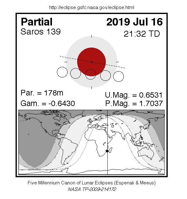
A partial eclipse of the Moon occurred on Tuesday 16 July, 2019 UT, lasting from 18:43 on 16 Jul–00:17 on 17 Jul UT. The Moon was strikingly shadowed in this deep partial eclipse which lasted 2 hours and 58 minutes, with 65% of the Moon in darkness at maximum. The eclipse was visible from South America, Europe, Africa, south Asia, and Australia.
The timings of the phases of the eclipse are as
follows. You would have been able to see each phase of the
eclipse if the Moon was up at the corresponding time as
seen from your location; however the penumbral phase
would have been very difficult to see in practice:
| Penumbral eclipse began: |
18:43:53 UT |
| Partial eclipse began: |
20:01:43 UT |
| Maximum eclipse: |
21:30:43 UT |
| Partial eclipse ended: |
22:59:39 UT |
| Penumbral eclipse ended: |
00:17:36 on 17 Jul UT |
During this eclipse the Moon was just 4 days before apogee, making it fairly small.
At maximum eclipse it was 0.507° in apparent
diameter, which is 4.5% smaller than average.
The statistics page has information on the ranges of the sizes of
the Sun and Moon, and the Moon data page displays detailed
information on the Moon's key dates.
Interactive Map
This map shows the visibility of the eclipse. The bright area in the
middle saw the whole eclipse; the yellow band to the right saw
the start of the eclipse, and the blue band to the left saw the
end. Note that the map is approximate,
and if you were near the edge of the area of visibility, the moon was
very close to the horizon and may not have been practically visible.
You can use the zoom controls to zoom in and out, and pan to
see areas of interest. Hover your mouse over the
tags to see what was visible from each area on the map. The green
marker in the centre shows where the Moon was directly
overhead at maximum eclipse.
The interactive map is currently not available.
Overview Map
This map sourced from NASA Goddard Space flight Center: GSFC Eclipse Web SiteGSFC Eclipse Web Site
The primary source of all the information on eclipses presented here at Hermit Eclipse. (NASA Goddard Space flight Center)
shows the visibility of the eclipse. (Click on it for the
full-sized version.)
Eclipse Season and Saros Series
This eclipse season contains 2 eclipses:
This was the 21st eclipse in lunar Saros series 139.The surrounding eclipses in this Saros series are:
This Saros series, lunar Saros series 139,
is linked to solar Saros series 146. The
nearest partner eclipses in that series are:
Eclipse Parameters
| UT Date/time (max) | 21:30:44 on 16 Jul UT |
TDT Date/time (max) | 21:31:55 on 16 Jul TDT |
| Saros Series | 139 |
Number in Series | 21 |
| Penumbral Magnitiude | 1.7037 |
Central Magnitiude | 0.6531 |
| Gamma | -0.643 |
Path Width (km) | |
| Delta T | 1m11s |
Error | ± 0m05s (95%) |
| Penumbral Duration | 5h34m |
Partial Duration | 2h58m |
| Total Duration | |
| |
| Partial Rating | |
Total Rating | |
| Sun Distance | 152050600 km (102.5%) |
Moon Distance | 398890 km (84.5%) |
| Sun Diameter | 0.525° |
Moon Diameter | 0.499° - 0.507° |
| Perigee | 04:55 on 5 Jul UT |
Apogee | 00:01 on 21 Jul UT |
| Contact p1 | 18:43:53 on 16 Jul UT |
Contact p2 | |
| Contact u1 | 20:01:43 on 16 Jul UT |
Contact u2 | |
| Max eclipse | 21:30:43 on 16 Jul UT |
| Contact u3 | |
Contact u4 | 22:59:39 on 16 Jul UT |
| Contact p3 | |
Contact p4 | 00:17:36 on 17 Jul UT |
Note that while all dates and times on this site (except
where noted) are in UT, which is within a second of civil time,
the dates and times shown in NASA's eclipse listingsGSFC Eclipse Web Site
The primary source of all the information on eclipses presented here at Hermit Eclipse. (NASA Goddard Space flight Center)
are in the TDT timescale.
The Sun and Moon distances are shown in km, and as a
percentage of their minimum - maximum distances; hence 0%
is the closest possible (Earth's perihelion, or the
Moon's closest possible perigee) and 100% is
the farthest (aphelion, the farthest apogee).
The statistics page has information on the ranges of sizes
of the Sun and Moon, and the Moon data page displays detailed
information on the Moon's key dates.
Data last updated: 2015-06-21 22:11:46 UTC.