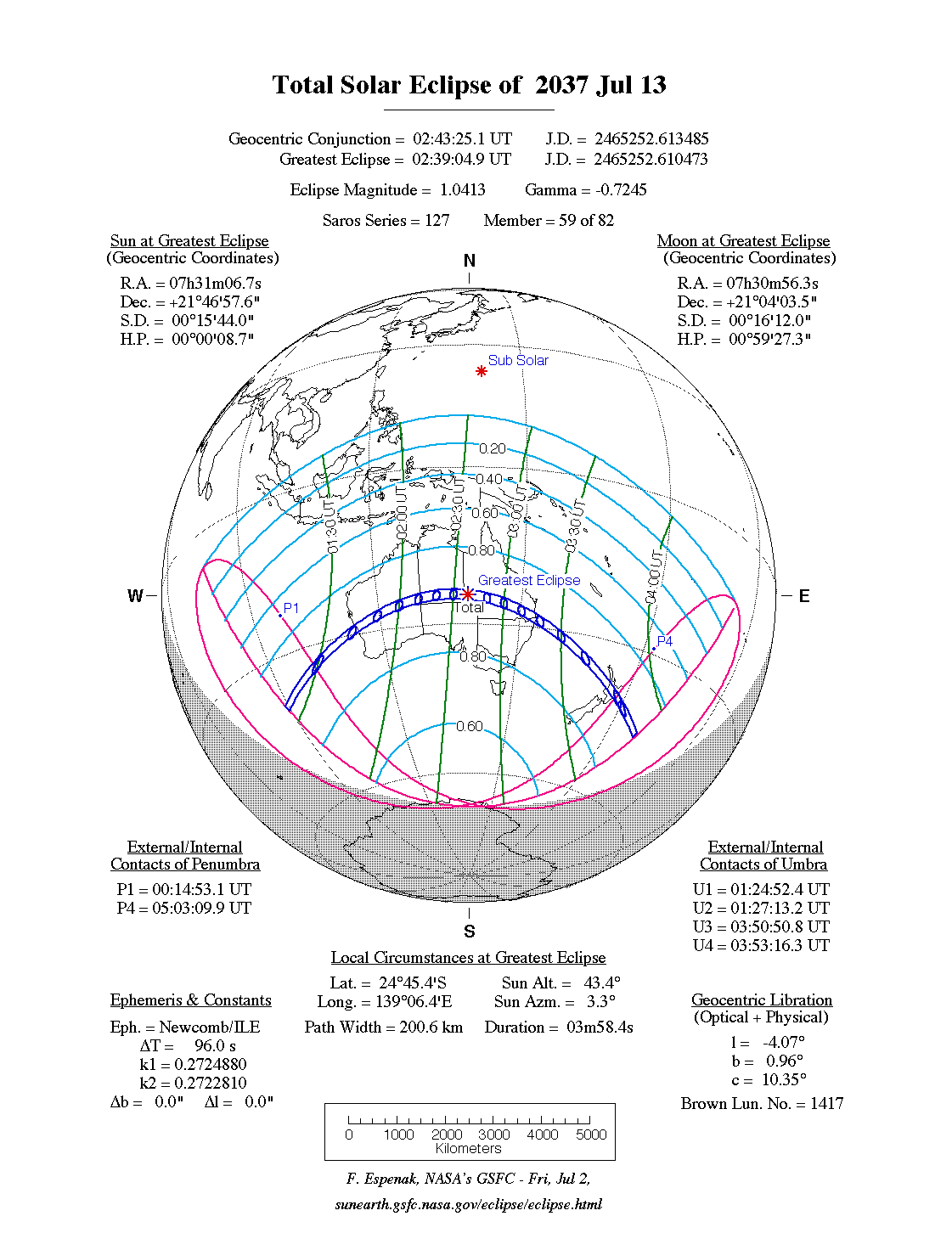
A total eclipse of the Sun occurs on Monday 13 July, 2037 UT, lasting from 00:14–05:03 UT. A dramatic total eclipse will plunge the Sun into darkness for 3 minutes and 58 seconds at maximum, creating an amazing spectacle for observers in a broad path up to 201 km wide. It will be seen across central Australia and in the North Island of New Zealand. The partial eclipse will be visible in southern Asia and Australia.
The timings of the phases of the overall eclipse
worldwide are as follows. In any particular
place it will be seen for a significantly shorter
duration as the shadow moves across the Earth:
| Partial eclipse begins: |
00:14:53 UT |
| Total eclipse begins: |
01:24:52 UT |
| Maximum eclipse: |
02:39:05 UT |
| Total eclipse ends: |
03:53:16 UT |
| Partial eclipse ends: |
05:03:10 UT |
During this eclipse the Sun will be 0.524° in apparent
diameter, 1.6% smaller than average. The Moon will be just 2 days before perigee, making it relatively large.
At the start and end of the eclipse the Moon
will be 0.540°, and at maximum eclipse 0.546°,
which is 2.8% larger than average; hence it will cover the Sun,
making this a total eclipse.
The statistics page has information on the ranges of the sizes of
the Sun and Moon, and the Moon data page displays detailed
information on the Moon's key dates.
Australia
The total eclipse begins in the southern Indian Ocean, and makes landfall in Western Australia just north of Dongara at around 01:41 UT. The southern Houtman Abrolhos islands will see the total eclipse, as will Geraldton, though they are north of the centreline and so won't see the full duration, which is 2 minutes 55 seconds on the centreline.
The eclipse track moves east across Australia, but without many people to see it; however, Mount Magnet will have a spectacular view of the total eclipse, lasting over 3 minutes at this point, at around 01:46 UT.
At 01:58 UT the total eclipse passes the area just east of Lake Carnegie, where the total eclipse of December 2038 will also be seen. It then passes into the Northern Territory at about 02:10 UT; a tiny sliver of the total eclipse will be visible in South Australia, but it will be very short-lived there. At 02:20 UT, the eclipse passes south of Finke Gorge, an area which will also see the total eclipse of May 2077.
Alice Springs is on the northern edge of the track, so residents would be advised to get 90 km (55.9 miles) or so south to see the full effect of a total eclipse lasting 3 minutes 52 seconds on the centreline at around 02:22 UT.
The eclipse reaches maximum at 02:39 UT, just after it crosses into Queensland. At 02:41 UT it passes Lake Machattie, whiere the total eclipse of July 2028 was also seen. It then passes close to Mitchell at 03:03 UT, giving viewers there an amazing total eclipse lasting 3 minutes and 47 seconds. At 03:08 UT, it passes near Surat, which saw the total eclipse of November 2030. The path of totality then curves down to hit the coast just south of Brisbane, which will be on the very edge of the eclipse path; for the best view of the eclipse, head down to Ocean Shores, which is right on the centreline, and will see an eclipse lasting well over 3 minutes at about 03:16 UT. The total eclipse of 2093 passes through the same area.
New Zealand
The eclipse path reaches the North Island at Nukuhakari Bay at around 03:46 UT. The eclipse is waning at this point, but will still last 2 minutes 24 seconds on the centreline. Napier is just off the centreline, and will see the eclipse a minute later as it whips across the island; Napier and Hastings should both see a memorable eclipse if the Sun is in view as it sets.
The eclipse finally passes just north of the Chatham islands and ends in the ocean to the east.
Interactive Map
This map shows the visibility of the eclipse.
The shaded area will see the total solar eclipse; however, near the edges of
this area, the eclipse will be very short. The bold line shows the centre
of the path, where the eclipse will last longest, so this is where you want to be if possible.
Use the zoom controls to zoom in and out; hover your mouse over any
point on the centreline to see the time and
duration of the eclipse at that point. You can pan and zoom the map to
see detail for any part of the eclipse path.
The interactive map is currently not available.
Overview Map
This map sourced from NASA Goddard Space flight Center: GSFC Eclipse Web SiteGSFC Eclipse Web Site
The primary source of all the information on eclipses presented here at Hermit Eclipse. (NASA Goddard Space flight Center)
shows the visibility of the total solar eclipse. It also shows the broader area in which a partial eclipse will be seen. (Click on it for the
full-sized version.)
Eclipse Season and Saros Series
This eclipse season contains 2 eclipses:
This is the 59th eclipse in solar Saros series 127.The surrounding eclipses in this Saros series are:
This Saros series, solar Saros series 127,
is linked to lunar Saros series 120. The
nearest partner eclipses in that series are:
Eclipse Parameters
| UT Date/time (max) | 02:39:13 on 13 Jul UT |
TDT Date/time (max) | 02:40:36 on 13 Jul TDT |
| Saros Series | 127 |
Number in Series | 59 |
| Penumbral Magnitiude | |
Central Magnitiude | 1.0413 |
| Gamma | -0.7246 |
Path Width (km) | 201 |
| Delta T | 1m23s |
Error | ± 0m18s (95%) |
| Penumbral Duration | |
Partial Duration | |
| Total Duration | 3m58s |
| |
| Partial Rating | major |
Total Rating | major |
| Sun Distance | 152072836 km (103.0%) |
Moon Distance | 368808 km (24.7%) |
| Sun Diameter | 0.524° |
Moon Diameter | 0.540° - 0.546° |
| Apogee | 19:51 on 3 Jul UT |
Perigee | 16:49 on 15 Jul UT |
| Contact p1 | 00:14:53 on 13 Jul UT |
Contact p2 | |
| Contact u1 | 01:24:52 on 13 Jul UT |
Contact u2 | 01:27:13 on 13 Jul UT |
| Max eclipse | 02:39:05 on 13 Jul UT |
| Contact u3 | 03:50:51 on 13 Jul UT |
Contact u4 | 03:53:16 on 13 Jul UT |
| Contact p3 | |
Contact p4 | 05:03:10 on 13 Jul UT |
Note that while all dates and times on this site (except
where noted) are in UT, which is within a second of civil time,
the dates and times shown in NASA's eclipse listingsGSFC Eclipse Web Site
The primary source of all the information on eclipses presented here at Hermit Eclipse. (NASA Goddard Space flight Center)
are in the TDT timescale.
The Sun and Moon distances are shown in km, and as a
percentage of their minimum - maximum distances; hence 0%
is the closest possible (Earth's perihelion, or the
Moon's closest possible perigee) and 100% is
the farthest (aphelion, the farthest apogee).
The statistics page has information on the ranges of sizes
of the Sun and Moon, and the Moon data page displays detailed
information on the Moon's key dates.
Data last updated: 2015-09-17 04:54:30 UTC.